 |
|||
|
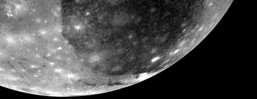
View
of Ganymede from the Galileo spacecraft.
|
|||
| THE SURFACE OF GANYMEDE | |||
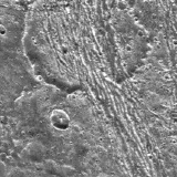
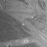
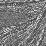
| A look at the surface of Ganymede shows two major types or terrain. There are dark heavily cratered regions and brighter bands called "sulci" (singular sulcus) which means groove or furrow. The dark terrain and the sulci are roughly equal in coverage. | |||
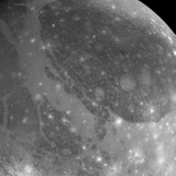 Galileo Regio and Uruk Sulcus from the Galileo spacecraft. |
 Voyager 2 close-up view of Nipper Sulcus. |
||
| The reflectivity of the surface is an indicator of the amount of rocky debris mixed in with the ice. The relative brightness of the banded terrain suggests that it contains less rocky debris and fewer impurities than the surrounding materials. The dark materials are also quite rough and hummocky, another sign that they have rocks embedded in them. | |||
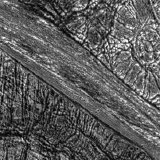
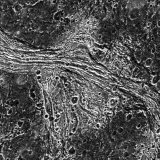
| Although these terrain types were known from Voyager images, it was the Galileo spacecraft that first revealed the fine surface detail. The image below of Galileo data overlaying older Voyager data shows the dramatic difference. Voyager resolved details as small as 1.3 kilometres, whereas Galileo images allow features as small as 74 metres to be discerned. In this case Galileo's on-board computer was overwhelmed by the visual richness of Ganymede and started to truncate image lines. | |||
 Uruk Sulcus seen by Voyager and Galileo. |
|||
| Dark regions | |||
| The dark cratered regions are interpreted as being quite old, recording the early history of the Solar System when cratering rates were higher. The cratered surfaces are thought to be between 3.0 and 3.5 thousand million years old. This makes them younger than the cratered highlands of our Moon. The lighter bands are interpreted as being younger still, because they have fewer craters. | |||
 The dark terrain of Galileo Regio. |
|||
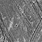
| Within the dark plains there are surfaces with quite different textures. Some have lots of short curved grooves which appear to be randomly oriented. These landscapes are referred to as "vermicular". Other surfaces are cut by short straight furrows, some of which have a regular alignment, some random. | |||
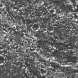
 Computer-generated perspective view of Galileo Regio ridges. |
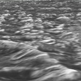 Computer-generated perspective view of Galileo Regio ridges. |
 Computer-generated perspective view of furrows and craters in Galileo Regio. |
|
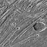
| Some areas of dark terrain are rougher and more hummocky. There are no boundaries between the different types of dark terrain, such as those between the dark and bright areas. The different styles of dark terrain simply grade into one another. Dark terrain on Ganymede has clearly suffered from tectonic forces - the crater in this part of Nicholson Regio has been torn apart by a lane of ridges and grooves. | |||
 Damaged crater in Nicholson Regio. |
|||
| The boundaries between bright and dark terrain are usually quite abrupt. The southern region of Galileo Regio demonstrates this clearly - dark fractured terrain can be seen either side of a 15 kilometre wide band of bright terrain, also fractured. The fractures in the dark terrain run at different angles, indicating that the forces responsible have operated in different directions. | |||
 Abrupt transitions between bright and dark terrain. |
|||
| The abrupt transition from dark to bright terrain is demonstrated above as north-south Erech Sulcus cuts across the older dark terrain of Marius Regio on either side. Erech Sulcus is in turn terminated in the south by east-west Sippar Sulcus. | |||
 Crosscutting sulci within Marius regio. |
|||
| However, it is not always the case that there is a sharply defined boundary between bright and dark terrain. Galileo imagery of Nicholson Regio shows three terrain types. Firstly, the bright, smooth terrain strip looking almost like an artificial road. Secondly, the heavily fractured surrounding dark terrain, and finally what appears to be an intermediate type of terrain, joining the bright strip. The intermediate terrain appears bright in lower resolution Voyager images and may be a type of transition between bright and dark terrain types. | |||
 Intermediate terrain type in Nicholson Regio. |
|||
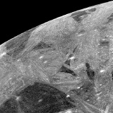
| Sulci | |||
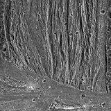
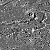
| The lighter banded sulci, composed of ridges and grooves, run for thousands of kilometres and are widespread on the surface of Ganymede. They form complex patterns, they intertwine and are braided. Similar ridge and groove terrain is seen on a number of other moons, including Enceladus, Miranda and Ariel. Only the large dark region of Galileo Regio is relatively free of sulci. | |||
 Sunset over Nippur Sulcus. |
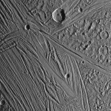 Tiamat Sulcus and Kishar Sulcus at sunrise. |
||
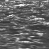
| The size of the bands varies a lot, some are very broad approaching 500 kilometres across. These are accompanied by much thinner bands spanning just a few tens of kilometres. Like the banded terrain on Europa most of the sulci of Ganymede have relief of just a few hundred metres. Some of the ridges though are much higher and rise up to 700 metres above the surrounding surface. | |||
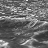
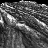 Computer-generated perspective view of ridges in the Uruk Sulcus region. |
 Detail of Uruk Sulcus. |
||
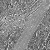
| The bands are disjointed, nudged about by movement of the surface and cut through each other as well as the dark terrain. | |||
 Philus Sulcus cutting through Nippur Sulcus. |
 Ridges and grooves within Uruk Sulcus. |
||
| The mechanism behind the formation of the banded terrain is still not yet understood. There is ongoing debate how it was formed. It is generally agreed that they are tectonic in origin, but the details are unclear. | |||
| Tidal forces could have heated and caused convection of Ganymede's mantle earlier in its history. If the interior was circulating, sections of the surface may have been pushed and pulled about like plates on Earth's surface. The heat from accretion and decay of radioactive elements might also be expected, on a world the size of Ganymede, to have driven tectonic processes. | |||
| These effects do not appear to have resurfaced the whole of Ganymede. There is also evidence that the crust has stayed in more or less the same place. Examination of the crater distribution shows that the leading edge of Ganymede (the front face of Ganymede as it orbits Jupiter) has more craters than the trailing edge. If the crust had moved about much there would probably be an even spread of craters. | |||
| More likely, the bands are related to cooling. Cooling of Ganymede with the expenditure of its internal heat, would have led to expansion of the surface as the water crust changed from one type of ice to another with a less compact structure. At different temperatures and pressures the molecular arrangement of ice changes. This may have caused the surface to split, but would not have opened up very wide gaps. | |||
| In one theory, water leaked or erupted through these narrow crevasses in the crust then spread out onto the surrounding areas. The problem with this idea is that the erupting water might have produced rugged or at least wavy edges. | |||
| There is a more convincing explanation which accounts for both the straight edges and the width of the bands. It suggests that the surface moved apart very slightly allowing broad sections of the surface to collapse. These trenches or "graben" then filled with cleaner water which came up the through faults either side. The walls of the graben prevented the liquid from flooding the surrounding plains. A good example is Lagash Sulcus which cuts through heavily cratered dark terrain within Marius Regio. Deformation, and any historical flooding, is clearly limited and has not affected surrounding terrain. | |||
 Lagash Sulcus cutting through the dark terrain of Marius Regio. |
|||
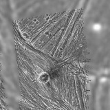
| The grooves and ridges on the bands simply formed by further extension and settling in place of the new surface. Liquid water erupted through these new faults and froze soon after it reached the surface. High-resolution imagery of part of Sippar Sulcus reveals structures that contain flow-like features. The central depression, 20 kilometres wide, with walls and terraces, appears to have been partly filled by flowing material. Is this evidence for the flow of ice-lava ? There may have been some sort of volcanic eruption with a resultant flow that cut a channel into the surface. | |||
 Flow-like feature possibly caused by ice volcanism. |
 High-resolution Galileo view of Sippar Sulcus. |
||
| The light banded materials are the only form of ice-volcanism identified on Ganymede with any certainty. Ganymede, before it cooled and its crust thickened, probably endured much more volcanic activity than is apparent from its modern surface. | |||
|
|
|||