 |
|||
|
A
coral reef island in the South China Sea.
|
|||
| WATER ON EARTH | |||
| The Earth is unique among the planets in having abundant supplies of water at its surface. Water sustains life and is involved in virtually all geological processes on the surface of the Earth. 97% of Earth's water is in the form of liquid water in the ocean basins; 2% is locked up as solid ice in the polar icecaps and continental glaciers; 0.6% is groundwater held in soils and rocks; 0.01% flows in rivers and lakes and 0.001% is water vapour and droplets in the atmosphere. Water is continually exchanged and recycled between these reservoirs in the hydrological cycle, being evaporated from ocean to atmosphere and rained out on the land to flow back to the oceans. These exchanges and transport mechanisms have done much to sculpt the landforms visible on the Earth's surface. | |||
| Rivers | |||
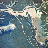
| When the ground becomes saturated with water, surface runoff results, with water flowing over the Earth's rocks and regolith. Stream networks result, providing a conduit for the water and a mechanism for erosion of the landscape. Weathered rock debris is transported in the stream flow, scouring out deep V-shaped channels in fast-moving streams in upland areas. Erosion rates are greatest in high upland areas where rivers quickly transport sediment to lower altitudes. The Himalayan Mountains and Tibetan Plateau, comprising 5% of the land surface, is the source of 25% of the sediment input to the worlds' oceans. | |||
 The Brahmaputra River creates a floodplain in the broad Assam Valley, one of the wettest places on Earth. |
 The Fraser River has deposited a large sedimentary delta on the Pacific coast of North America. |
||
| In lower land, where the stream flow is reduced, some of the sediment load is deposited, perhaps blocking the river and changing its course, producing features such as alluvial fans at the base of cliffs, meanders and ox-bow lakes on flood-plains, and braided channels within the riverbed itself. | |||
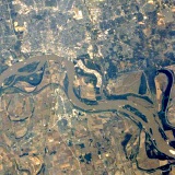 The Mississippi River with oxbow lakes - evidence of its former stream channels. |
 The River Congo splits into many streams as it flows across its very flat basin. |
||
| When low land with a mature, meandering river is uplifted, the river flows faster due to its increased gravitational potential energy, and can start to cut down once again. The Grand Canyon in North America is an example of such a rejuvenated river, containing many incised meanders, which have cut 1600 metres down through the underlying rock strata. | |||
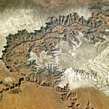 The Grand Canyon, snow-covered in this winter view. |
|||
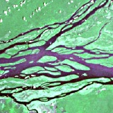
| Lakes | |||
| Lakes form in local topographic lows, perhaps formed by glacial scouring, rocky debris or sedimentation. Circular crater lakes occur in the eruption craters or calderas of volcanoes (usually extinct), or in meteorite impact craters. Most lakes have an outflow river which continues to flow down to sea level. In arid areas, a large portion of a lake's water may be lost by evaporation and there may be no outflow. Such lakes may be seasonal, filling up during rainy times and leaving a salt residue behind after the water has evaporated. | |||
 A lake in the Andes Mountains, coloured by eroded rock in the meltwater of the glaciers that feed it. |
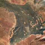
 A chaotic drainage system of rivers and lakes in Asia's Chang Jiang River Basin. |
 Cooper Creek, Australia : A large outwash plain subject to flash floods in an arid area. |
|
| Oceans | |||
| The oceans cover 77% of the Earth's surface and give "the blue planet" its dominant colour. Sediments accumulate at the edges of the continents on the continental shelf and around mid-ocean islands, brought to the ocean by river waters. The continental shelf off the Atlantic coast of North America consists of a pile of sediments several kilometres thick, topped by 3 metres of sand which continue to be moved around by ocean tides and currents. Tides are caused by the gravitational attraction of the Moon. Surface currents are largely driven by pressure and wind systems in the atmosphere above. | |||
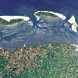 Mud and sandbanks are exposed at low tide in the Fresian Islands. |
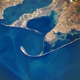 Wave action can shift coastal sediment into sandbars and spits. |
||
| Large slumps of sand or mud can give rise to turbidity currents which move very fast down slight slopes due to the increased density of water containing suspended material. Deep gullies and canyons have been eroded on the sea bed, particularly in the continental shelf sediments. | |||
 Deep canyons in the continental shelf of Monterey Bay, California. |
|||
| Sediments also accumulate right across the ocean basins from the chemical deposition of dissolved minerals. The calcium carbonate shells of dead sea creatures sink and accumulate as oozes on the deep ocean floor. In contrast to the canyons of the continental shelf, the deep ocean floors are the flattest places on the planet. The mid-ocean ridges are where new Earth crust is created by the extrusion of lava at tectonic plate boundaries. | |||
 Parallel ridges flank the central rift valley between the Pacific and Juan de Fuca plates. |
 Tectonic fractures in the floor of the Southern Ocean. |
||
| Like the atmosphere, the oceans are responsible for heat flow from the equatorial regions to the poles. This spreads energy from the sun over the surface of the planet, evening out extremes of climate. Similar to the Hadley circulation cells in the atmosphere, a global circulation system has been suggested for the oceans, whereby warm waters are carried poleward at the surface, and returned as cold, dense water in the ocean depths. This "great ocean conveyor belt", with a turnover period of more than 1,000 years, is a key part of the global climate system. Unlike the atmosphere, ocean circulation is restricted by the position of the continental landmasess, with exchanges of water between the ocean basins being quite limited. | |||
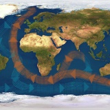 The Great Ocean Conveyor global circulation pattern. |
|||
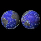 Average surface currents for Earth's oceans. |
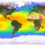 Global sea surface temperatures over a ten-day period. |
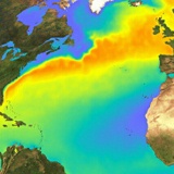 The colours here represent temperature relative to the latitudinal average in the Gulf Stream. |
|
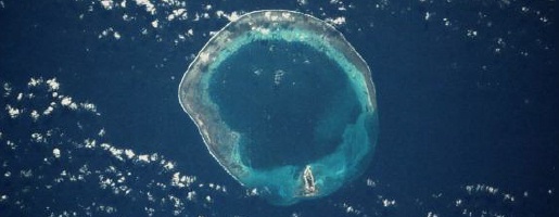
| Some ocean lifeforms secrete calcium carbonate shells to protect themselves as they move through the water. Others anchor themselves to rocks in shallow seas, leaving behind their "skeleton" calcium carbonate as a coral reef structure when they die. Coral reefs are found on carbonate platforms in shallow water on the continental shelf and in mid-ocean. Mid-ocean coral reefs initially grow in the shallow water around a volcanic island. As volcanic activity ceases, the island starts to erode and subside, but the coral colonies continue to grow if they stay within the sunlit top 20 metres of the ocean. In this way, circular atolls are formed, with great thicknesses of limestone above the sites of extinct volcanoes. | |||
 The Great Barrier Reef: a 2000 kilometres-long reef system on the continental shelf. |
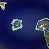 South Pacific : mid-ocean reefs surrounding subsiding volcanic islands. |
 Pearl and Hermes Atoll, part of the Hawaiian chain in the Pacific. |
|
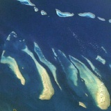
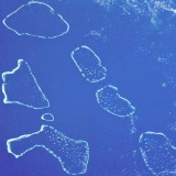 The Maldive Islands, a string of more than 2000 coral formations. |
|||
| Ice | |||
| A significant portion of Earth's water is in solid form as ice and snow. There are permanent icecaps in both polar regions - frozen sea water (sea ice) in the Arctic and Southern Oceans and continental icecaps on Antarctica and Greenland. | |||
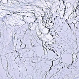
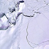
| The Antarctic icecap contains more than 90% of Earth's permanent ice in a sheet averaging 2 kilometres thick. The area covered by sea ice varies through the year, ice cover in the Southern Ocean increasing fourfold between summer and winter. Icebergs can break off where the continental icecaps meet the sea and float great distances in the southern and northern oceans. | |||
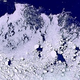 Thin ice floes at the edge of the sea ice in the Weddell Sea. |
 Thick pack ice with a few leads of open water. Weddell Sea. |
 The edge of the Ronne Iceshelf, Antarctica. |
|
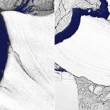 The fracturing of large icebergs at the Filchner Iceshelf between 1973 (left) and 1986 (right). |
|||
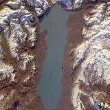
| There are smaller icefields in Earth's high mountain ranges. Glaciers occur where winter snowfall survives the summer thaw and accumulates. This occurs on land above the snowline, which varies with latitude - glaciers are found at 5,500m on Mount Kilimanjaro near the Equator, above 4,500 metres in the Himalayas (30 o North) and 2,800 metres in the Alps (50 degrees). | |||
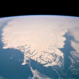 The southern tip of Greenland, with sea ice and icebergs streaming down the east coast. |
|
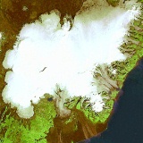 Vatnojokul, Iceland - Europe's largest icecap. |
|
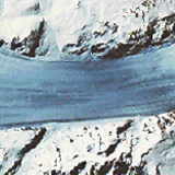
| Ice is a major agent of erosion in areas above the snowline, and many glacial erosion features survive from the last ice age, when continental icecaps grew across much of North America and Eurasia. Steep mountain peaks are produced by freeze-thaw action and other weathering processes, with debris falling onto the glaciers below. Glaciers themselves carve out broad U-shaped valleys and transport debris both within and on top of the body of ice. | |||
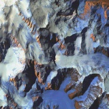 The flanks of Mount Denali, Alaska, heavily eroded by glacial action. |
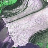 The Hubbard Glacier, Alaska, showing dark lateral moraines. |
||
| Lines of debris, called moraines, are carried downslope at speeds up to 75 metres per year. Most debris is deposited at the downslope margin of the glacier - the terminal moraine. If glaciers and icefields retreat due to a warming climate, such features can be left thousands of kilometres from the nearest icefield. Glacial debris can block valleys, causing lakes to develop. Large chunks of debris can be left scattered as erratic boulders. | |||
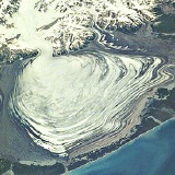 Malaspinas Glacier, Alaska, a piedmont glacier with layers of dark terminal moraine. |
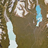 Lakes in New Zealand's Southern Alps, dammed by glacial moraine and fed by glacier meltwater. |
||
| Very large-scale features can have a glacial origin : North America's Great Lakes occupy glacially-scoured depressions and Cape Cod is a terminal moraine. Sea level was at least 80m lower during the last ice age and Cape Cod is just one of many glacial features flooded when sea levels rose. The fjords of Norway, New Zealand and the southern Andes are deep glacial valleys flooded by seawater. | |||
|
|
|||