 |
|||
|
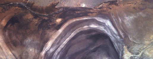
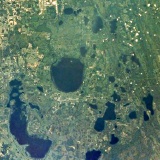
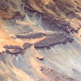
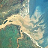
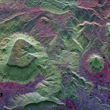
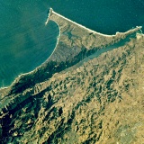
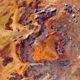
Historical
shorelines give the Lop Nor saltflat in Asia its distinctive appearance.
|
|||
| THE EARTH'S SURFACE | |||
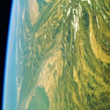
| The Earth's surface is young in geological terms, mostly less than one thousand million years old. This surface age indicates a geologically active planet, with evidence of the intense bombardment period of the early solar system having been largely obscured by crustal deformation, volcanic activity, erosion and deposition. The large-scale features of the Earth's surface, such as mountain ranges, rift valleys and ocean trenches, are controlled by the continuing motion of sections of the crust. This process, termed plate tectonics, seems to be unique to Earth among the terrestrial planets in the present day. Another striking feature of Earth's surface is the abundance of water - evidenced not just by the extensive oceans, but by the water erosion features which have shaped the land. Much of the continental landmasses are covered by a regolith of weathered debris - soils, muds, sands and loose rock - which provides a foothold for most of the planet's lifeforms. | |||
| Volcanoes | |||
| Earth is a volcanic planet - apart from the major eruptions on the continents, there is continuous activity along the oceans ridges, creating new oceanic crust. Volcanoes have played a part in shaping the Earth's surface, and have had a role in altering the early atmosphere - a process that continues today. | |||
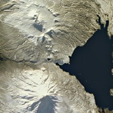 Kamchatka Peninsula. Secondary cones have grown from the floor of an old caldera (top), in contrast to the younger volcano (bottom). |
|||
| More about Earth's volcanoes | |||
| Impact craters | |||
| Not all surface features are generated by Earth's geological processes - the Earth has in the past suffered bombardment from space. Many other Solar System bodies have surfaces completely covered with impact craters, and our nearest neighbour, the Moon, is also heavily cratered. However, although much of the evidence of Earth's early bombardment has been obliterated, the surface still retains the scars. | |||
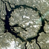 Manicouagan, an impact crater remnant in the ancient Canadian Shield. |
|||
| More about impact craters | |||
| Weathering | |||
| In addition to the recycling of the Earth's rocks due to plate tectonics, the Earth's solid surface is kept relatively young by the actions of the atmosphere, the hydrosphere and the biosphere. Sedimentary rocks are the result of the erosion, transport and deposition of bedrock material. | |||
| Exposed rock is weathered physically and chemically by exposure to the atmosphere, surface water, plant and animal life. Rock faces are physically broken down by freeze-thaw action or the growth of plant roots in fractures and joints. More important, however, is chemical alteration, which occurs due to water solutions behaving as weak acids - particularly the solution of atmospheric carbon dioxide in rainwater, carbonic acid. | |||
| One third of Earth's sedimentary rocks are clays - alkaline rocks produced by the chemical weathering of silicates. Other rocks are chemically weathered by dissolving completely. Carbonates (limestones) show distinctive "karst" landscapes, particularly in wet tropical climates, where large underground caverns have developed and the overlying surface has collapsed. These sinkholes can often be found filled with water. | |||
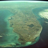 Florida has many sinkhole lakes, a result of the chemical weathering of limestone. |
 The low-lying Florida Peninsula of North America. |
||
| Low-silica igneous rocks also dissolve completely. When the silicate structure dissolves in iron-rich silicates, the iron is oxidised by oxygen and hydrated by water to produce hydrated iron oxide, or limonite, more commonly known as rust. Iron is an important part of low-silica igneous rocks such as basalt, and limonite is a commonly-found weathering product, colouring soils and staining rocks shades of red and brown. It is the same mineral that gives the surface of Mars its characteristic colour. | |||
 Variations in colour give clues to the chemical composition of rock layers in the Spring Mountains, Nevada. |
 Oxidised metals give desert sands a distinctive red colour, in contrast to the dark sandstone bedrock of the Tassili Mountains, North Africa. |
 The red dunes of the Namib Desert. |
|
| The result of weathering is the regolith of loose mineral material which blankets most of the land surface. When mixed with organic material, the regolith is termed soil and is the source of nutrients for most of the planet's plant life. The proportion of organic material in the soil varies from the dry, mineral sands of the deserts to the wet, organic-rich soils of the evergreen forests. The organic material is from decaying plants and animals and tends to darken the colour of the soil. | |||
| Erosion | |||
| Loose material is more easily transported by gravity, wind, water and ice flow, generating more loose material along the way. The Earth's regolith is thus not only a product of weathering, but helps accelerate weathering and erosion. Gravity is the driving force behind the erosion of the surface, tending to move the regolith to the lowest possible point. | |||
| Mass wasting is the movement of bodies of rock or regolith largely due to gravity, rather than due to a transporting medium such as water. Examples of mass wasting processes include slope failures, such as slumps, rockfalls and rockslides, and sediment flows, such as soil creep, mudflows and avalanches, where the regolith is mixed with water and air. Talus slopes are mass-wasting features consisting of angular debris accumulated at the base of cliffs. Mass-wasting can be triggered by events such as earthquakes, volcanic eruptions, heavy rain and undercutting by a stream or the sea. | |||
| Drainage systems arise where groundwater reaches the Earth's surface and starts to flow downhill. The resultant stream and river channels carry rock fragments, soil and dissolved substances to lowland areas and the oceans. Once established, stream channels become the focus for erosion, slopes becoming steeper as the channels deepen. Most landscapes on Earth consist of river valleys separated by higher ground - the result of a combination of weathering, mass wasting and stream erosion. | |||
 Extensive talus slopes have accumulated at the base of these cliffs in Mauritania, North Africa. |
 The eruption of Mount Pinatubo coincided with heavy rain, producing fast-moving ash and mudflows (lahars). |
||
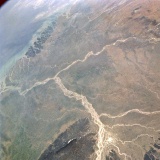
| River drainage patterns typically have a dendritic or tree-like form, with tributaries branching from the main channel, like the limbs of a tree, as we move upstream. Weaknesses in the underlying bedrock can modify this arrangement, with strongly jointed rocky terrain producing a rectangular pattern, and ridges of resistant rock resulting in a "trellis" pattern. A large peak, due to a dormant volcano or a domed uplift, produces a radial drainage pattern. | |||
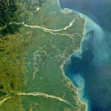
 Dendritic drainage along river estuaries on the West African coast. |
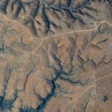 Relatively young drainage pattern in the Jabal al Qamar, Arabia. |
||
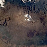 Radial drainage pattern on the slopes of Mount Kilimanjaro, East Africa. |
 Older drainage pattern, Jabal al Qamar, Arabia. |
||
| Sediments | |||
| Sediment carried from upland areas is deposited downstream. Alluvial fans accumulate at the foot of steep slopes, where the speed of water suddenly slows and sediment is deposited, blocking the stream and causing it's path to wander. Floodplains of fertile soils accumulate in lowland areas where rivers periodically flood. Each flood leaves a thin layer of sediment behind. Deltas of sediment extend from coasts, and sediment fans build up across the continental shelf. | |||
 Alluvial fans (left) at the base of the Sheep Range, Nevada. |
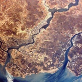
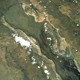
 The Rivers Ganges and Brahmaputra (above) ; a huge floodplain at the edge of the Indian subcontinent. |
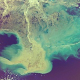
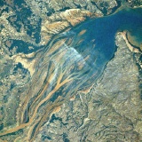 Islands at the mouth of the Betsibokoa River, Madagascar, created from recently-deposited sediments. |
|
 The Godvari and Krishna Rivers have both built large deltas out into the Bay of Bengal. |
 Two great rivers, the Uruguay and Parana, meet to form the River Platte estuary in South America. |
||
| In the marine environment, coarser-grained sediments such as gravels accumulate near the coast, with finer-grained sands and silts travelling further, distributed by currents in the water. Muds travel furthest, settling in calm, sheltered or deep waters. Buried by subsequent deposits, the sediments are compacted to form sandstone, siltstone, mudstone and conglomerates (derived from gravels). | |||
 The Mississippi Delta has migrated east and west, building up successive layers of sediment. |
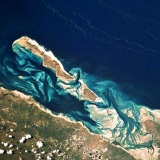 Sandbanks have built up in sheltered waters off southern Africa. |
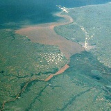
 Rivers such as the Pungoe bring a heavy sediment load into the Mozambique Channel. |
|
| As well as the physical processes outlined above, sedimentation may be due to chemical processes. Calcium carbonate (limestone) is the most common chemical sediment, being extracted from seawater by invertebrates and secreted as shells. Large carbonate platforms, such as that underlying the Bahama Islands, can build up in shallow water areas of the continental shelf away from land-derived sediments. Simple lifeforms play a widespread role in chemical sedimentation in the oceans, from algal mats which trap carbonate sediment, producing stromatolites in tidal flats, to the microscopic calcite plates of coccolithophores that produce deep sea oozes which are buried and compacted to form chalk. | |||
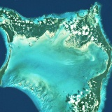 Crooked and Aklins Islands shelter an area of shallow water. |
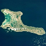 Much of the interior lagoon of Kiritimati is filled with coral growth. |
||
| Sedimentary beds of different composition may overlie each other, producing stratification in the rock. The different strata were deposited under different conditions at different times. Marine sediments accummulate slowly, but can build up vast thicknesses over millions of years, particularly if tectonic processes cause the coastal zone to subside. | |||
 James Ranges, Australia. The thinner rock strata at the top of the image have been tilted up and exposed by erosion. |
 Radar imagery highlights different rock layers in southeast Asia's Phang Hoei Range. |
||
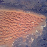
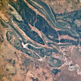
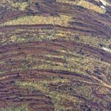
| Wind may play a significant role in sediment transport in arid areas, producing sand dunes with well-sorted grains. Rivers and lakes in arid environments are often seasonal or intermittent, with lake water evaporating to leave saline sediments such as salt and gypsum. This can happen on a larger scale in shallow seas with limited circulation in hot climates, and these evaporite sediments are fairly common on Earth. | |||
 A sandstorm in the Sahara Desert. |
 Windstreaks in the Sahara indicate the direction of the prevailing wind. |
 Linear sand dunes line up along the direction of the prevailing winds in the Simpson Desert, Australia. |
|
 Irregular, almost star-shaped dunes in the Tiferene region indicate shifting winds. |
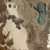 Lake Poopo is a shallow saltlake on the Andean Altiplano. |
 Historical shorelines give the Lop Nor saltflat its distinctive appearance. |
|
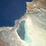 The Kara Bogaz Gol saltflat is periodically flooded by the Caspian Sea, resulting in a thickness of evaporite deposits. |
|||
| Tectonic plate motions can bring coastal and even deep ocean sedimentary rocks to the surface. Uplifted strata may be folded, fractured and upturned, forming mountain ranges with ridges of resistant rock and valleys of weaker rock. Sedimentary rock is subjected to the same forces of weathering and erosion as apply to igneous rock, and is eventually recycled back to sea level as sediment. | |||
| Deformation | |||
| Tectonic forces driven by the Earth's internal heat flow are continually acting on the rocks of the crust. These forces exert stress on rock strata, sometimes causing them to warp, buckle or fracture. The type of deformation depends on a number of factors, including the composition of the rock, the temperature, confining stress due to overlying rocks, and the time over which the stress builds up. | |||
| Deformation of rocks may be brittle, causing fractures, or ductile, causing bending. If movement occurs along a fracture, the fracture is termed a fault. Movement occurs along a fault when stress builds up enough to overcome the frictional forces between the surfaces. Movements tend to be abrupt and are often associated with earthquakes - very large movements due to the rebound of elastically deformed of rock. | |||
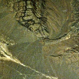
| Faults may produce horizontal or vertical displacement. An example of horizontal displacement is the San Andreas Fault, where rocks on different tectonic plates are sliding past each other, roughly north-south. An example of vertical displacement is the African Rift Valley, where east-west tension due to divergent plate sections has caused the area between two parralel faults to drop. Such a rift valley is also known as a graben. The opposite situation, where the central section is left higher than the flanking sections is known as a horst. A half-graben is where a single fault has caused a section to drop and rotate, as found throughout the Basin and Range Province of the western USA. | |||
 The San Andreas Fault has produced a large horizontal displacement at Point Reyes, California. |
 Lake Eyasi occupies the floor of a rift valley, part of the Great East African Rift System. |
 The Yoshino Valley Fault Zone near the Japanese town of Kobe, site of a devastating earthquake in 1995. |
|
 The Basin and Range province of horsts and half-grabens in western North America. |
|||
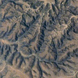
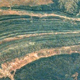
| Bends in rock are termed folds, and they are due to gradual, ductile deformation over a long period of time. The simplest fold is a monocline, where the dip of the strata becomes steeper. An anticline is an upfold in the form of an arch. A syncline is a downfold in the form of a trough. A series of folds may be gentle (open), or tightly closed up; symmetrical or asymmetrical. Tight asymmetrical folds may be pushed over one another so much that fracture occurs and a thrust fault develops. | |||
| Folding eventually exposes different rock strata to erosive processes and the weaker rocks erode more quickly, leaving the stronger rocks standing higher. Fold patterns may be discerned in many of the Earth's mountain ranges. | |||
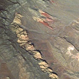
 Gently folded rock strata exposed near the Ahaggar Massif in North Africa. |
 The James Ranges in Australia are a series of low ridges which seem to be the result of the erosion of a syncline structure. |
 Intensive folding and thrusting in the Appallachian Mountains(left) has produced a series of long ridges. |
|
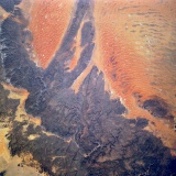
 The extensive Makran Foldbelt was produced by the collision of India with Asia. |
|||
|
|
|||