 |
|||
|
The
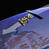
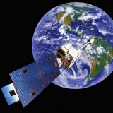
International space station
|
|||
| EXPLORING THE EARTH | |||
| By the beginning of the twentieth century, most of the Earth's land surface had been explored and mapped. While there had been a few voyages of scientific discovery, most expeditions were mounted to expand trading opportunities or for territorial gain. A few blank areas remained at the poles and in the interiors of South America and Asia. A number of technologies were developing which would make it easier to explore inaccessible areas of the Earth's surface, as well as opening up the rest of the solar system to our gaze. | |||
| Aerial photography | |||
| Photography was developed in the nineteenth century, providing a means to make a visual record of an object, event or location. As cameras became smaller and lighter, they were carried aloft by balloons, kites and even pigeons. Early aerial photographs were used for military reconnaissance and as souvenirs from fairs and public exhibitions. | |||
| It was the advent of powered flight in 1903, however, that made it possible to photograph large areas of ground in a very short time. Once recorded on film, images can be analysed in detail back in the laboratory. Using knowledge of the geometry of the camera and flightpath, measurements can be made on the images and translated back into the "real world" to provide the basis of a map of the area. Overlapping images give stereo coverage, enabling the height of the ground to be measured and contours drawn around the Earth's three-dimensional surface. | |||
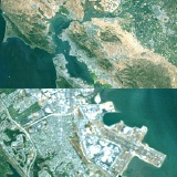
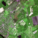 Low-altitude aerial photographs are the source data for most new maps. |
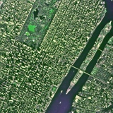 This high-altitude air photo shows New York City's Central Park. |
||
| During the 1920s and 1930s, specialist air survey cameras and stereo viewing equipment were developed, greatly reducing the need for ground survey and speeding up the preparation of topographic maps. World War 2 saw the widespread use of aerial reconnaissance and the development of photo-interpretation skills for intelligence-gathering and map-making. After the war, an army of skilled personnel was available to conduct air surveys across the world, and this is now the standard method of producing new maps. In the second half of the century, the same techniques have been applied to images of Earth and the other planets taken from space. | |||
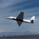 A high-altitude ER-2 aircraft, used by NASA to test new Earth observation sensors. |
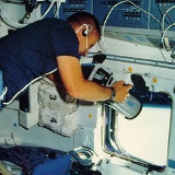 Astronauts on the Space Shuttle use large-format survey cameras to photograph the Earth. |
||
| Rockets and satellites | |||
| For centuries, rockets have been used by the Chinese for military and entertainment purposes. In the twentieth century, pioneers such as Robert Goddard turned to using rockets to explore the atmosphere and the fringes of space. After World War 2, German expertise in rocket propulsion and guidance was harnessed by the United States and the Soviet Union to develop sub-orbital ballistic missiles as well as launch vehicles that could place payloads in orbit. | |||
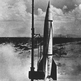 A German V2 rocket is tested in the United States in 1946. |
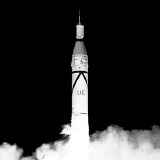 America's first successful spaceshot: the launch of Explorer 1 in 1958. |
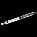 A model of Explorer 1, the first American satellite to orbit the Earth. |
|
| Russia's Sputnik was the first artificial satellite to achieve orbit in 1957, followed the next year by America's Explorer. Radio communication links returned data from instruments on satellites, including high radiation counts measured at certain altitudes by Explorer-1 (the Van Allen Belts), and the first picture of the Earth from space, captured by a television camera on Explorer-6. | |||
 The first military reconnaissance satellite photo was a grainy picture of an airfield in Siberia, taken in 1960. |
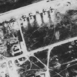 By 1969, American spy satellites were taking photos detailed enough to distinguish different aircraft types. |
||
| The use of electronic sensors, magnetic recording of their signals, and radio transmission to ground receiving stations on Earth was to be the basis of future Earth observation and planetary exploration missions, although photographic film was to be used on military reconnaissance missions requiring extremely high detail for twenty years, and continues to be used by astronauts today. | |||
| Checking the weather | |||
| Like Explorer-6, the TIROS weather satellites used a tv camera to snap pictures of Earth's cloud cover throughout the 1960s. From 1964, the Nimbus series carried a number of experimental instruments for atmospheric and ocean science. Atmospheric temperature profiles were measured for the first time over open ocean areas and through cloud cover. Surface temperatures in the mid ocean could now be regularly measured and the sea ice front in the Southern Ocean could be accurately charted for the first time. | |||
 The NOAA weather satellite orbits from pole to pole at 800 kilometres altitude - a low polar orbit. |
 The GOES weather satellite is in an equatorial orbit at 35,800 kilometres - the geostationary orbit where satellites appear fixed over one location. |
||
| In 1970, TIROS was replaced by the NOAA Polar Orbiter series which used a telescope and a scanning mirror to obtain more detailed pictures. Many receivers were installed worldwide typically receiving 8-10 images per day. More frequent coverage became available in 1974 when the first GOES satellite was placed in geostationary orbit, imaging the entire western hemisphere every half hour, enabling rapidly-evolving hurricanes to be tracked. | |||
| These instruments revolutionised weather forecasting as well as providing valuable tools for observing and understanding atmospheric processes. The NOAA series will continue into the new century and the GOES satellites are now complemented by Meteosat, covering Europe and Africa, Insat, covering the Indian Ocean and central Asia, and GMS, covering Japan and the western Pacific. | |||
| Imaging sensors | |||
| The principle of the scanning camera tested on Nimbus and deployed on the NOAA Polar Orbiters was further refined for the Landsat series of satellites. Landsat-1 was launched in 1972, using a more powerful telescope than Nimbus and NOAA. Landsat's Multispectral Scanner (MSS) recorded digital images with a pixel size of 80 metres and an image coverage of 185 kilometres. The image is built up line-by-line as the satellite's orbit carries it over the Earth's surface at an altitude of 900 kilometres. A sun-synchronous orbit ensures that Landsat views any part of the Earth's surface at the same local time of day - approximately mid-morning. | |||
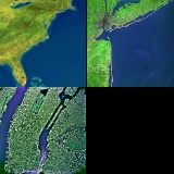 Earth observation systems cover a range of scales: NOAA/AVHRR weather images are about 2,500 kilometres across (left); Landsat MSS covers 185 kilometres (centre); Air photos cover less than 10 kilometres (right). |
 A full Landsat Thematic Mapper image covers 185 kilometres (left). The full-resolution extract (right) shows features larger than 30 metres. |
||
| In addition to two channels at visible wavelengths, MSS used two near-infrared channels, making it sensitive to changes in vegetation cover. Following the convention established with colour infrared aerial photography, MSS images are often shown with heavily-vegetated areas appearing red. Landsat-4, launched in 1982, carried a new scanner, the Thematic Mapper (TM), with seven wavelength channels and a spatial resolution of 30 metres. The new channels extended further into the infrared, enabling different rock types to be distinguished. | |||
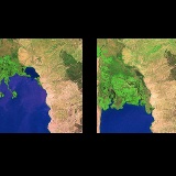
 A false-colour infrared Landsat image (left), compared with a natural-colour photograph of the same area (right). |
|||
| Other instruments are sensitive to other parts of the electromagnetic spectrum: The Total Ozone Mapping Spectrometer (TOMS) on Nimbus-7 uses ultraviolet wavelengths to measure ozone concentration in the stratosphere. Radiometers on the NOAA satellites are sensitive to thermal emissions at infrared wavelengths, enabling them to measure sea surface and cloud-top temperature. Particularly cold surfaces such as sea ice emit at longer wavelengths and are sensed with passive microwave radiometers. | |||
 Satellites view the Earth's surface through gaps in the cloud cover. This composite image shows large areas continually cloud-covered during a 10-day period in 1992. |
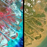
 Satellite images are used to monitor landscape changes such as this expanding delta on Lake Turkana, imaged by Landsat in 1973 (left) and 1989 (right). |
||
| Active microwave instruments, which illuminate the surface with their own energy and measure the reflected signal, include imaging radars and radar altimeters. They have the advantage of operating at night and through cloud cover, but the factors affecting the reflected signal are many and complex, so radar images can be difficult to interpret. | |||
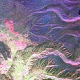 Radar images appear bright where the surface is rough or contains strong reflectors, such as the city of La Paz in this multi-frequency image taken from the Space Shuttle. |
|||
| Radar altimeters have been flown on several satellite platforms, including Seasat, Geosat and ERS, measuring the distance to the Earth's surface to within a few centimetres. Over the ocean, altimeters reveal variations in the Earth gravity field as deep sea water "piles up" over large crustal features below. The topography of large areas of the seafloor has been inferred from altimeter measurements, filling in the gaps between sparse ship-borne depth soundings. New crustal features have been found beneath areas continually covered by sea ice which have never been surveyed from ships. | |||
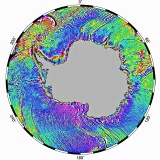 Radar altimeter measurements were used to create this gravity map of the Southern Ocean. |
|||
| Astronaut Photography | |||
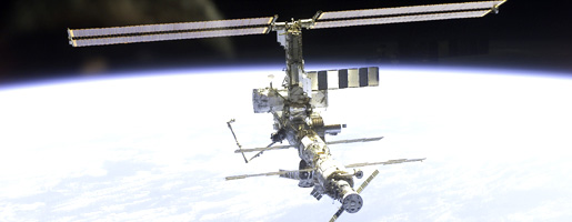
| The International Space Station (ISS), due to be completed in 2008, is a collaborative project involving the USA, Japan, Canada, ESA members, and Russia. The 450 ton orbiting research facility is located at an altitude of 400 kilometers and completes an orbit of the Earth in 90 minutes. | |||
| In addition to the wide variety of biology and technology microgravity experiments carried out on the station, ISS will be used to conduct astronomical observations and monitor the Earth. Astronauts will be able to select and photograph useful targets such as extreme weather phenomena and other naturally occurring events (volcanic eruptions, flooding), or man-made disasters (oil-slicks, forest fires), which robotic satellites are often unable to provide timely coverage of. | |||
| Aboard the Space Shutttle, Skylab and the Russian MIR space station earth-observation and photography were carried out, and rated as one of the tasks most enjoyed by crews on longer missions. Already from the International Space Station, many superb pictures have been obtained by astronauts with hand-held cameras. The space station is planned to operate for ten years after its completion date and will provide many excellent opportunities for Earth observation. | |||
|
|
|||