Nightsky's Options Window allows you full control over the operation of the program. As well as determining the current behaviour of the program it can generate files of settings which can be loaded at any time by dragging them to the program icon, so you can have different sets of program options always available for different purposes. It can be opened either from the opening menu, or by pressing Shift-F1 when a map is displayed.
The window has a large panel on the left, a section of which is on view at a time, controlled by the vertical scroll bar, and five action icons on the right which are always on view. Note that any changes you make are at first confined to the options window; you manipulate here a copy of NightSky's settings, not the settings themselves. The five action icons function as follows when clicked on. (Note that clicking with ADJUST will keep the options window in view, with SELECT it vanishes.)
OK
Click here to make the settings in the Option Window current, so that NightSky will use them for future map plots.
Cancel
Abandon the Option Window settings and leave NightSky's settings as they were when the window was opened. Always closes the options window.
Save
Open a save dialogue box to enable you to save the settings in the option window as a text file. If the resulting file is dragged to the Nightsky icon on the icon bar, it will be recognised and those settings enforced. Saving also makes the settings current that is the action is OK and Save.
Default settings
Overwrite the present NightSky settings with those in the file of choices that NightSky uses on initialisation (normally ChoicesD in NightSky's own directory).
Use now
As OK, and if the map window is open, also re-plot the map to reflect the new settings. Click here with ADJUST to keep the options window in view.
The left hand part of the window is divided into a number of panels which will be described in turn.
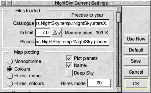
Files Loaded
This panel gives information on the data files that NightSky is currently using, namely the star catalogue and the file of places.
If you click SELECT on the text in the first line, Catalogue, a message will be shown telling you about the catalogue in use - either the standard one or the special zodiacal one for occultation predictions.
In this message box, a click on Cancel closes it, Next switches between the two catalogues ("X" and "S"), and OK enters that catalogue into the options window. It is not of course loaded until the new options are enforced, as described above. For the X (normal) file only, you can set the extent of it that is to be loaded by clicking SELECT or ADJUST on the blue bump arrow. You are informed how much memory this catalogue size will consume.
Similar clicks on the other Place line yield a message only but no action:
Place files can only be loaded by dragging them to the program icon, or by editing a choices file in a text editor such as !Edit.
Note that the default choices file used on initialisation can only be changed by editing (in a text editor) NightSky's !Run file. Find and alter the line
Set NightSky$Opts <Obey$Dir>.ChoicesD
towards the end of that file. Edit and resave, making sure you do not change the file type (Obey file).
Precess to Year
This switch, if on will cause a star catalogue to be processed to the start of the current year on first being loaded, and subsequently whenever the year of the map being plotted alters. The year in question is displayed on the icon bar under the NightSky icon. Precessing the catalogue from the Icon Bar Menu does not by itself turn this switch on: it must be explicitly set here. Switch it on if you want to see the stars in their exact positions, but leave it off if for example you want to see where today's planets would be in the sky if we had the stars of say BC5000. As always where precession is involved, plotting will be much quicker if you can operate satisfactorily with a small catalogue size, say the minimum 5.4 magnitude limit.
Map plotting
Plot planets - This switch is normally on. You might turn it off if you wanted to produce a series of maps showing the sky at your location at different times of year: in order to be valid for any year Planets must be deselected. This switch will be turned off automatically if you plot so far from the present epoch that there is a risk of the attempted calculation crashing the programme.
NightSky cannot maintain accuracy of calculation over tens of millennia. You will need to re-selcct planet plotting from this present window after an adventure of more than 27000 years into the past or future. Real accuracy for the planets, sun and moon is of course confined to much narrower limits from the present day, typically a few centuries. An interesting test is the near-discovery of Neptune by the world's then only telescopic observer, Galileo Galilei on 1612 December 28 at around 3am. He saw Neptune in the same telescopic field as Jupiter, whose satellites he had discovered and was observing, and even noticed that it had moved the next night in relation to the fixed stars. Had he investigated this obscure and faint object further, the actual discovery of Neptune might well have been anticipated by 233 years. NightSky shows Neptune around 0.1° east of Jupiter and very slightly south of it, which is what Galileo drew in his notebook.
Names - This puts the name of each planet found beside it. The switch is ignored if Plot planets is off.
Deep Sky - Turn this switch on to have these objects added to the map. NightSky's catalogue contains 267 assorted deep space objects, each classified as one of the following five types.
The different classes of object are colour coded in a simple way, which, like all colours in NightSky can be adjusted by you.
Many of the objects included here (especially planetary nebulae) are very faint, far fainter than the faintest stars known to NightSky, but all can be seen either with binoculars or a modest telescope. Once Deep Sky is turned on, these objects can be identified, found and tagged as normal.
Map plotting action
One of the four "radio" buttons here will be on, indicating the currently chosen way of drawing the map. Two sets of colours are provided for use with NightSky; the first set is used when colours is chosen, the other when monochrome is chosen. In fact they can be any two sets of colours you want, as they are all user-definable. Notionally the first is what you want to see on screen and the second is what you want to send to the printer. The other two options here, hi-res colour and hi-res mono will, if free memory allows, keep the map as a sprite in a specified mode, whereas the usual action is to use the current display mode. This will not improve the appearance of printed labels on your map, as when a Draw file is rendered to the printer the full resolution of the printer is utilised, which is much higher than that of the screen. However it will improve the resolution of the printed images of stars, the horizon, and the milky way as these are simply dumped to the printer.
Map saving
One of the four options in this panel -will always be chosen, and this will determine how maps arc saved. CSV here stands for Comma Separated Variable, a text file with a simple standardised structure.
Squashed - This switch, if selected will cause saved Draw or Sprite files to be saved in compressed form. Since star maps contain huge areas of one colour, they compress markedly, 10% or less of initial size being not unusual for smaller field settings. If you want to assemble a demonstration using NightSky's automatic save routine it is much better to select this action unless you have a large hard disc that you do not mind filling up temporarily with star maps! The squash process itself needs some extra temporary workspace - if this cannot be made available when NightSky asks for it, the save will be a normal (unsquashed) one: no error is reported. Note that squashed files must be unsquashed by 'Squash before they can be transferred to Draw, Paint, Impression, Ovation and similar packages.
Any save method as selected in this window may be overridden at the actual save time by another choice from the Save map submenu of the map menu. That choice then becomes the currently selected method. The map is re-plotted if need be.
The Moon
This panel has two sets of "radio" buttons to control how NightSky handles the moon. It can be ignored, plotted normally or the Plot 31 days option can be chosen. This last is intended to be used when you use NightSky to produce a map that is part of a monthly article on the sky seen from your location. Such articles regularly appear in newspapers and might also appear in say a school or sailing club magazine. The moon's position will be shown on the map as it is at the original time and also every other day for a month ahead, in each case at the time for which the map is now correct. Thus if the original plot is for 2200 hrs local time on the 1st of the month, the moon will be shown in its correct position then, and at 2152 on the 3rd, 2144 on the 5th, and so on, in each case labelled with the day of the month in the font and size selected for user labels.
The other pair of radio buttons control the time over which NightSky's Occultation routine looks for events. By default this is a year, but you can change this to a single month if preferred. Remember that such a search can always be terminated cleanly by pressing Escape at any time after it has started.
Constellations
There are three independent switches in this panel.
NightSky deals with the constellations in a straightforward manner. With each constellation is associated a single key point. If this point is above the horizon, that constellation is added to a list of active ones. After the stars have been plotted the names, boundaries and joins of the active constellations are plotted. Therefore a constellation that is partly above and partly below the horizon may or may not have its name plotted or be joined up. Boundaries will always be plotted in full, because if for example the boundary between Leo and Virgo is plotted because Leo is active, then Virgo will be added to the active list even if its key point is below the horizon, and all its boundaries currently above the horizon will be dealt with. For this reason when. Boundaries is selected there will be a more complete plotting of the Joins for those constellations that are rising or setting.
Some constellations are small, and naming all of them on a small scale map would produce excessive clutter. The 89 constellations (there are only 88 really but one, Serpens, is in two separate parts) arc therefore reduced to 49 areas by regarding each of the small constellations as associated with a larger one; or possibly several small faint ones are linked together. This can affect the look of the map. For example on a whole sky map, if Lyra is near the horizon it will not be joined up or labelled unless the key point of Cygnus is visible, and similarly the Southern Cross won't be processed unless the key point of Centaurus is above the horizon. On large scale maps NightSky will usually join up all the constellations on screen, unless the scale is very large and not a single key point is within the map area. In this case the Join and Boundaries constellation options are automatically deselected, and will remain so even if you zoom out to whole sky. You must choose them again from this window to get them plotted. In fact you would not normally find joins or boundaries helpful when plotted on a field of only a few degrees, so this action of NightSky is appropriate.
Co-ordinate Grid
Nightsky supports four different co-ordinate grids for its maps.
The resolution of the grid plotted depends on the scale of the map. For whole-sky views it is 30°, and for the largest scales supported in NightSky it is 5°.
Two or more grids superimposed are confusing and unhelpful. Therefore if more than one type of grid is selected the second, third and fourth (if chosen) have only their central line (equator) plotted. The priority is given by the order of the explanations above. Thus if RA/dec and Ecliptic are both selected, just the ecliptic itself will be added to the grid of RA and declination previously plotted. If the Central line (equator) only switch is on then only the equator will be plotted for all grids selected.
Small crosses are always plotted at the visible pole(s) of a grid.
The default choice in NightSky as supplied is celestial equator and ecliptic only plotted, as in the example panel above. This is a generally useful setting.
Auto-labelling
This important panel gives you full control over which stars are automatically labelled when NightSky plots a map.
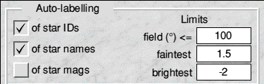
The writable fields under Limits determine whether or not auto-labelling will take place at all. If the field exceeds the maximum you enter, it will not. When auto- labelling is on, only stars within the magnitude range given will be labelled. Both the brightest and faintest values are inclusive (stars of those values will be labelled). As an example, the values shown ensure that the brightest 25 stars, those of the "first magnitude" (or brighter) will be labelled, others not.
Naturally, the smaller the field of the map, the fainter the stars that you can label without excessive clutter. In the northern hemisphere it is usually helpful to have Polaris, the Pole Star, labelled. Its magnitude is 2.0. However some regions of the sky contain quite dense concentrations of bright stars with long names which then get plotted on top of each other, most confusingly.
If you want to use a 2.0 or fainter limit in a whole sky map and this overlapping occurs, you can correct it by editing your Draw file in !Draw before printing. From Draw's menu choose Select all and then Ungroup and Clear. You can then, with a little patience, select and reposition problem labels so that all can be read, or of course delete a few. A simpler solution is to stick to the 1.5 limit for whole-sky maps and then label Polaris by hand!
As NightSky plots the stars, it puts in a buffer the reference numbers of stars that might require a label, because they are within the specified range of brightness; it adds the actual labels at a later stage. Should the buffer become full, auto-labelling will be discontinued, but no error reported. The buffer has room for around 1000 stars, far more than could profitably be labelled on a single map, so this should not be restrictive.
There are three label types that can be chosen.
Star IDs
This small panel controls the appearance of Star Information windows. Greek letter names will produce labels such as "lambda Sco = Shaula" in this window. Those not averse to greek letters may prefer to select the Greek letters icon. Labelling of star IDs in the main map window always uses Greek letters, as does the Find Star window.
Note that when using Greek letters in the Star Information or Find Star windows, but not the main map window, NightSky is obliged to temporarily switch the system font to Greek. This may affect open windows of other applications. However when these windows are closed the system font prevailing when they were opened is restored. If somehow an unwanted Greek system font has been set by NightSky, as can occasionally happen because more than one window requires it, press F12 and at the star prompt at the bottom of the screen and type "Alphabet Latin1" then press Return.
Fonts
The next panel controls the outline fonts and sizes used for NightSky's labels. The sizes (in points) on the right are writable: just click on the icon and the caret will be placed in it. Use Ctrl -U to clear the present value if appropriate. Press Return to move to the next size field below.
You cannot type into the font fields themselves. A click here pops up a menu of your available fonts from which you can choose. A click on the yellow arrow icon has exactly the same effect. As supplied, with the one exception of Star IDs, all the fonts set are Trinity.Medium, either plain or italic. NightSky will not work unless this font is available. If you change the settings and then run the program again in an environment where different fonts are available, then any fonts not found will be substituted with Trinity.Medium. No error message is given.
Title Font refers to the title bar that is attached to NightSky maps when saved as sprite or Draw files. The text of the title bar will be a copy of the title bar of NightSky's own map window, unless you edit it before saving. NightSky does not at the moment support changing this font. An information box appears if you try. You can of course change it once the map has been exported to the .'Draw application. Changing the size has no effect either. Your new value is accepted, but ignored, as the font is scaled to fit the rectangle NightSky draws for it before the save is effected.
Star IDs is more complicated than the other font selections because of the problem of mixed greek and latin letters (and numerals). NightSky needs to find a font that supports the greek alphabet here. If you do not have one, then it is suggested that you choose System font in this icon. Stars will then be correctly labelled. The result is rather "chunky" on a print out, though very acceptable on the screen. If System font is not chosen for star IDs, NightSky will check for Greek letters in the label to be printed. These are then printed in the font and size specified in the icons under discussion and all other characters appear in Trinity .Medium font.
Customising Greek Fonts
Most Greek Fonts available for Acorn's RISC OS machines mimic a Greek language typewriter rather strangely. The number codes are those of the corresponding latin letter, rather than what simple alphabetical ( = ap !) order would dictate. If you specify a Greek or maths/Greek font in NightSky and you do not get the correct labels then you must tell NightSky what the correct codes for the different letters are, and all should then be well. To do this:
You will probably need to amend like this all your NightSky choices files. As supplied, NightSky is set up to give correct labels with the Greek font supplied with Computer Concepts' Impression or the EFF MathGrcek font. Some maths/Greek fonts could have a different coding, but can be used successfully once the above procedure has been carried out.
The other labels
The remaining types of label, used for star proper names, magnitudes, constellation names, planet names and the user's own labels pose no problems. Remember that for a printed map the labels will need to be in very small sizes to look good, so small in fact that they will appear unclear on the screen. You may well choose to create a special file of choices for printed map5, and another for normal use. Then, once the map ia what you want, simply drag the print settings to the program icon, open the Options Window and click on Use now to impose the print-customised settings. Then save and print the map.
Colours
NightSky is supplied with two complete sets of colours, referred to within this Options Window as Colours and Monochrome , it being sensible to suppose one is for use on the screen and the other for sending to a monochrome printer. However you can vary either set as you want. Clicking on any of the coloured squares, or the labels to their left pops up NightSky's Colour Tool Window. When this opens it will display the label that you clicked on, together with the present setting in terms of red, green and blue components. These are given pictorially through the slider bars, and also displayed as percentages in the writable fields to the right. A large bar gives the best representation to this colour setting that the current display mode can offer (without dithering).
Using the Colour Tool
There are no less than five ways in which you can vary the setting of the colour in question.
Notes on particular colours
System font only onscreen
This final panel of the Options window is self-explanatory. Because labels of very small size which print well are virtually unreadable on the screen, NightSky lets your labels onscreen be in the system font, whilst using the chosen font for the label in the Draw file being created. The four switches here are independent of one another. Note that Planets is not included here: if they are named then the appropriate font and size are always used.
This option has no meaning unless one of the Draw file saving methods is in force.
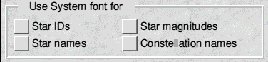
A related problem can also occur. If you want large print labels on a large scale map, then when displayed on a whole sky view there will usually be so many of them that the display gets confused. Therefore NightSky disregards large settings of font size on small scale maps. You get the large labels you want as soon as you zoom in however.