NightSky has three main menus: the Icon bar menu and the Draw a Map menu are accessed from the icon bar, and the Map menu which is accessed by clicking MENU when the pointer is within a map window.
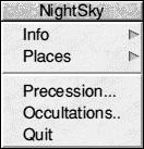
Click MENU on the program icon to open a menu containing five items -
Info
This leads to a standard information box giving your version of the application and its date.
Places
This leads to a submenu of three items, each of which in turn leads to a dialogue box. They will be discussed in reverse order.
Places -> Save places
This will save a file of places used by NightSky after editing. The filename in the usual save box will initially be that of the place file NightSky is configured to load on initialisation. To change, alter the leaf name (after the final dot), and then click OK or press Return. This applies if the new file is to be stored in your Nightsky directory. Otherwise, delete by typing Ctrl U , enter your own leaf name and drag the file icon to the directory display of your choice.
Places -> Create new file
Following this arrow will remove all but the first ("Default") place from memory. You would choose this option to create a totally new places file.
Note that the default place cannot be deleted, though it can of course be edited. If you choose this menu option by mistake, drag a places file from the NightSky directory into the empty dialogue box window, or to the program icon, and the places lost are restored.
Places -> Show places
Use this choice to examine and edit the current file of places.
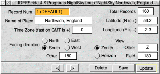
Clicking SELECT on the right/left arrows will move to the next/ previous record. Holding the key down will cycle rapidly through the available records. Using ADJUST will reverse this effect. Ctrl-SELECT (hold down the Ctrl key and press SELECT ) on the relevant arrow will take you to the first record and the last record respectively.
Adding a new record
Clicking SELECT on the right arrow when the last record is on display will give a blank box ready for entry of a new record at the end of the file. You must enter something in the writable fields for place name, latitude, longitude, and time zone. By default the Field and Direction are both set to 180°, which gives a whole sky view facing south. This standard map makes it easy to compare views from different places: you can always zoom in on an area of interest after the first map is drawn. However, to edit the direction, click on one of the direction icons or enter your own value in the box. The zenith/horizon icons are relevant only if the field of view is less than whole sky. If you choose zenith, the map will be centred on the overhead point, if horizon then the horizon will be placed at the bottom part of the map; its extent is governed by your choice of the field. You may also type a value in the box to the right of this pair of icons. This will then specify the altitude above the horizon of the centre of the map (degrees, range 0°-90°). NightSky will ignore this if is not sensible, e.g. it leads to the area viewed being mainly below the horizon. Whole sky maps are always centred on the zenith, irrespective of your selections.
When you create a new record (or amend an old one) the values you type in the places dialogue box have no effect on the places stored in memory until you click on the Update icon. It is when you do this that the number of records is incremented if you are adding a new record, or the previous information is over-written if you are changing an old one. Update and Save will present you with a save box to store the new file away. Note particularly that when you are amending several records, for example editing their time zones to reflect daylight saving time, it is necessary to click on Update for every edited record before moving on to the next, otherwise the changes are lost.
Clicking on the Delete icon removes that record from memory and the total is adjusted downwards. You cannot delete record #1, the default place, which is a special record. You can of course amend it, and will naturally want to edit this record to reflect your actual location as soon as you have installed Nightsky.
Pressing MENU anywhere in the dialogue box causes a small menu of three items to appear:
If you close the places dialogue box after editing in any way, that is adding, changing or deleting records, changing the default location or sorting the records, you will be prompted to save the changes. You can decline this and save from the icon bar menu later if you prefer.
Precession...
This menu choice from the icon bar menu causes a small dialogue box to appear. You enter a year and when you then click on OK the catalogue currently in memory will be adjusted so that the co-ordinates are correct for the date entered (year and fractions of a year, for example 1993.5). NightSky does not support the saving of processed catalogues. The amount of computation involved is very large, and the hourglass will appear with a percentage indicating how the work is progressing. The calculation allows for the proper motions of the stars, that is their actual motions through space, as well as for the precession of the equinoxes which is just an alteration of the co-ordinates of the stars caused by a change in the direction in space in which the earth's axis of rotation points.
Precession of the Equinoxes is very slow: it takes some 26000 years for the complete cycle. It causes no readily perceptible alteration to the positions of the stars over a single human lifetime. On a whole sky map, its effect even over a century is insignificant. For routine studies of the night sky, precession may therefore be disregarded. However, the largest scale maps supported by NightSky have a field of 1/8°: scales of 1° or less would most likely be used for eclipses of the sun and moon, transits of Venus and Mercury across the face of the sun, and occultations of stars by the moon. On such maps ignoring precession even over the seven years between 1993 and 2000 (the epoch of the catalogues) could cause an error in star (not planet) positions amounting to one-tenth of the moon's diameter. To represent occultations adequately therefore, you must use a processed catalogue. This is the only context within NightSky for which this is the case, except when the effect itself is the object of study. After the catalogue has been processed, NightSky's icon bar icon is updated to show the (integer) year to which it applies.
Occultations...
A star is occulted when the moon lies directly between the observer and the star, which then cannot be seen. An occultation of a star (or planet) can last from a few seconds (for a grazing occultation ) to somewhat more than an hour. Occultations of faint stars are much more easily observed when they take place at the dark limb of the moon. This normally means that between new and full moon (seen in the evening skies) the disappearance is observable, and from full moon to new moon (seen in the morning skies), the reappearance of the star. Both can be seen readily for the brighter stars and planets.
Observation of occultations, especially of a bright star, makes a very suitable learning project for keen beginners in astronomy. The record made of the event should include drawings showing the phase and position of the moon, and exact timings. For a grazing occultation a star may disappear and reappear several times before finally vanishing. This is due to the irregular terrain of the moon: as the moon cuts across it, the star is occulted behind lunar mountains, but shines through valleys. Observations of such occultations are very valuable in refining knowledge of the moon, provided times are accurate to Is or better and position on earth is known exactly.
On choosing this option, a dialogue box allows you to set the place and start time of the search for occultation events. The results are deposited in a CSV file in the sub-directory Occns of the NightSky directory. The file will have a name like SydFeb93 , if say the place was Sydney and the search began in February, 1993. The time needed for a whole year's search will be an hour or even considerably more, depending on machine. You can see in the -window what date has been reached and how many events have been found, and interrupt the search at any time by pressing Escape. Other active applications will have no access to the processor while the search is in progress. The resulting file can be examined in a spreadsheet application such as Clares' Schema, or other application which understands the CSV file type and can format the display properly.
Technical Note
An event discovered is added to the file if:
Provided (in both the above cases):
1. star's altitude more than 5° if fainter than 2.0, or more than 9° if fainter than 5.0 and 2. sun's altitude less than -4° for stars fainter than 4.0. Occultation prediction filesThus bright stars and planets are predicted even in the hours of daylight.
Quit
This choice exits NightSky, removes the program icon from the icon bar, releasing memory claimed by the application. NightSky is not like a text handling application in that it is envisaged that you will generate many more maps than you will want to save or print. Therefore NightSky makes no complaint if the work on-screen is unsaved, but exits directly.
Click SELECT on the program icon to bring up a menu of four choices.
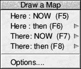
Here: NOW
Choosing this option will cause a map to be plotted immediately using the star catalogue and configuration set-up currently in force (that is according to the last file of choices loaded, possibly as amended subsequently by you). The map will be refreshed every minute after drawing (RealTime mode on.)
Here:then
Like the two following menu items, this choice leads to the map plotting dialogue box . In the present case it is presumed you want to alter the time but not the place, and the caret (text cursor) is in the year box. The time will not be reset, it will be whatever was last used for a map or other NightSky operation (now if there has not been one).
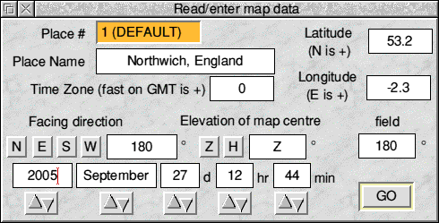
The simplest way to set the time is to use the blue bump arrows under each field. SELECT advances and ADJUST reverses the cycle. Holding the button down repeats this until you release it. You can also type in the date/time fields if you prefer: pressing Return will move the caret to the next box, except for the last, min. Pressing Return with the caret in min starts the plot, it is equivalent to clicking on GO.
You may also change the place or edit the location fields, in which case this menu choice is the same as There: then. See below.
RealTime mode is off: after plotting the map will not be refreshed.
There: NOW and There: then
These choices open the same dialogue box, but the caret is in the place name field. The place shown is the last one used by NightSky, and may be the default place. To bring up the required place remove the present contents of the field by typing Ctrl-U, enter a few characters of the name, and press Return. This operation is not case sensitive. The record appears, or if there is no match the current record is re-displayed. If you have chosen There: NOW then each time you bring up a place in this way the date and time boxes will show the present local time at the location, and after plotting RealTime mode will be on with update every one minute.
Alternatively you can click SELECT to cycle forwards through the available records, or ADJUST to go back. The process auto-repeats if the mouse button is held down.
You may change any of the location fields, for example you might "decide" to move Nottingham into the southern hemisphere with a judicious minus sign. The map will reflect your entries, but the place record is not altered and next time this dialogue box is opened the information will follow the record in memory, which you cannot amend from the present menu. The facility can be useful however, for instance to show how quite small changes in position can affect eclipses and occultations.
If you want to use a new location, add it to the file of records via the icon bar menu (Show places >), but don't save the file if your interest in the place is transient.
Options...
This opens NightSky's Options Window, which is an important and flexible part of the application. It allows you to control precisely the way map plotting is done and is described in full in Chapter 4. With the map window open, Shift-F1 has the same effect provided NightSky owns the caret, which it automatically does after a click in the map window.
Whenever a map is plotted from the opening menu, it will be placed in a window on screen that the first time fills the whole screen area, and later has the extent and position that it had when last closed. Note that if the menu choice was made using SELECT over Here: NOW or over GO in the dialogue box, the map will be opened in front of any other open windows. If ADJUST is used to click on the menu, the map window will retain its current position in the "stack" of open windows.
Mouse clicks in the Map Window
Within NightSky is stored a file of comments on a selection of interesting stars and deep sky objects (not the solar system). Any user can read this text by clicking on the TaQ icon in an information window. You can also enter up to seven lines of text on an object (press Return at the end of each line). However when you press on OK in the tagtext window, you must supply a password before your comments can be stored away. A small dialogue box appears.
Type the appropriate characters into the box: the corresponding text will not appear. When you have finished, press Return or click on OK; the window will disappear. If you now click on ok again in the tag window?, then provided you have given the correct code, the contents of the window will be copied to the tagtext file. Otherwise the password box will simply open again. Once gained, write authority over the tagtext file lasts for ten minutes, after which you will have to resupply it.
If security is not a problem you can see the password as you enter it by clicking on Show password. This reveals the text in the box and changes Show password to Hide password; a second click will hide it again.
The password for NightSky as initially set up is Achernar. The password checking process NightSky uses is case-sensitive (e.g. not ACHERNAR).
Editing the password
It requires a higher level of authority to set the password than to write to the tagtext file: otherwise it is possible to imagine that in say a school environment a student might configure the application so that only he or she had access. Proceed as follows:
Keep a careful note of your passwords, and in particular keep the security code in a safe (unshared) place. If they can mess it up for you, they will.
Click MENU anywhere in the map window to bring up the Map menu. There are ten options, which are arranged in three groups.
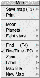
Save map
NightSky can save maps as sprites, CSV map instructions and Drawfiles, which are the best for hard copy. The CSV files allow NightSky to recreate the view and are very compact. Sprites are for hard copy if memory is too tight for a Drawfile. Sprites and Drawfiles (which themselves each contain a large sprite) can optionally be compressed as they are saved, using Acorn's Squash module. This will typically reduce storage space needed by a factor of ten or more. Save map -> leads to a submenu from which any of the above options can be chosen. If the chosen save method differs from the last one used, read from a file of choices on initialisation, or set from the Options window (whichever is most recent), then the new method becomes current. This means that it will be used in saves initiated by the hot keys F3, Shift-F3 and Ctrl-F3. (See below).
Automatic saving
After a first save has been made a save path has been defined. NightSky can make further saves automatically without having to pop up the save box: Shift-F3 and Ctrl-F3 will both do this. If the first saved map had the leaf-name NSmapl then the following ones will be NSmap2, NSmap3 and so on, and all will go into the directory you chose for the first save.
Shift-F3 causes the current map image to be stored in this way. On the other hand Ctrl-F3 , pressed during an animation, will cause even' image generated to be saved, until either RealTime mode is cancelled or Ctrl-F3 is pressed again. If the destination storage area becomes full (as can easily happen), the Filer will send you a message in an error box: you should cancel RealTime -when this happens. You -will probably only want to use this feature of NightSky if the current save method compresses the image to be saved.
Print ->
NightSky does not support direct production of hard copy at present. There are a number of ways in which your maps may be printed out. If memory is plentiful, then install !Paint or !Draw, and "save' the map by dragging the file icon in NightSky's save box onto the appropriate application's icon bar icon. You can then print it from within that application. Note that Draw files print much better, as printer resolution is much higher than screen resolution. Draw can exploit this when printing, but Paint just prints a copy of the screen.
If memory is not plentiful, say on a 1Mb machine, it is always possible to produce quality print-outs of your maps, but a little ingenuity has to be used. For a one-off print-out of a single map, an obvious way is to save the map to disc, exit NightSky, load 'Draw or !Paint, and then load the saved file into that application. (Double click on the saved file to achieve the same result in a single step). You can then print the file in the usual way.
If you want to avoid quitting .'NightSky, proceed as follows. First, produce the map using the star catalogue, screen mode and save method of your choice, preferably Draw files. When you have the map you want to print, make sure that RealTime mode is not selected, or the map may be over- written before you have finished with it. Now use the Options window (F1 , see Chapter 4) to adjust the star catalogue to minimum size. This will free a lot of memory, enough to install !Draw (or !Paint). Save the map into this application. With the file loaded in Draw or Paint, close the map window and deselect Draw file saving if selected. This will free yet more memory that the printer module can use.
Moon
Choosing this option pops up an information box on the moon, including a large image showing its phase (fraction of visible disc in sunlight) and orientation in the sky at the place and time of the map. The moon's north pole is marked with a letter N so that you can appreciate the orientation of its globe in space relative to yourself. The information given in the box refers in part to the moon's position as seen by you and in part to its objective location in space:
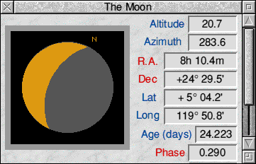
Altitude and Azimuth are relative to the observer, and so are Right Ascension and Declination , which locate the moon relative to the stars. The next two views are of a waxing crescent moon in the western sky seen at the same moment as figure 27, which was a view in latitude 5°N. The two in Fig 28 are from 55° N and S respectively, and all three places have the same longitude. You will note that there is a difference of as much as V/2 degrees in its position relative to the stars, and the further north your viewpoint is, the further south the moon appears in the sky. This is the effect of parallax and occurs because the moon is very close to us compared with any other astronomical object (Figure 29). NightSky allows for parallax affecting the positions of the sun and planets, as well as the moon; it is very much smaller in their cases.
Phase is the fraction of the area of the visible disc that is sunlit. This also is slightly dependent on your position on earth, as figure 29 shows.
The remaining data items are given relative to a fictitious observer at the centre of the earth (geocentric). The orbit of the earth around the sun defines a plane in space whose projection on the distant stars is a practically unchanging circle called the ecliptic. By definition the sun is always somewhere on it. The ecliptic provides a natural measuring system for the positions of objects in the solar system.
Longitude is the angle round the ecliptic from an arbitrary reference zero which is chosen as the position of the sun at the time of the northern spring equinox on March 20 or 21 each year. This is the vernal equinox, and the associated point of the ecliptic is technically named the first point of Aries, even though due to precession it is actually in the constellation Pisces.
Latitude is angular distance north or south of the ecliptic; the moon can be up to five or so degrees north or south of it. The other planets have similarly small inclinations (angles) of their orbits to the ecliptic and hence are always found close to the ecliptic and so "in" one of the familiar constellations of the zodiac - Aries, Taurus and so on. The exception is Pluto whose inclination is a high 17°.
Nodes: twice each month in its orbit the moon crosses the ecliptic, from south to north at the ascending node and from north to south at the descending node. Eclipses can only occur if the moon is close to one of these points at either full or new moon, and when it is sufficiently close an eclipse is inevitable. Figures 27 and 28 refer to December, 1992 and give the ascending node as 245° which is the sun's longitude in early December. Eclipses in 1992-3 thus take place in November-December (ascending node) or May-June (descending node). The nodes move steadily backwards around the ecliptic however, and by 1999, the year of the next British total eclipse of the sun, the moon will be at its ascending node in August. The nodes return to their original positions after 18 years 11 days and 8 hours, the famous Sams Cycle. The Saros was discovered in Iraq some three millennia ago and was and is used in eclipse prediction. After this interval the same conditions very nearly recur. So the famous and very long 6 minute 58 second total eclipse of the sun seen in Mexico on 1991 July 11, will have a successor on 2009 July 22 when an eclipse of practically the same duration will be seen from south-central China.
Age gives the time in days since last new moon, and is related to elongation which here is the (geocentric) angle between moon and sun. Similarly the moon's geocentric distance (in km) is related to its apparent size in the sky which can vary by some 7% either side of its mean value, which is why when an eclipse occurs at new moon, the moon is not always large enough to blot out the whole of the sun's disc, yielding an annular eclipse.
Planets ->
There is a sub-menu of three options .
Info
Opens the standard planet information window for the last-chosen planet (initially Mercury), as though you had clicked SELECT on the planet in the map, except that a click on field does not re-plot the map. Click anywhere within the window to advance to the next planet, and anywhere outside it remove it from the screen.
The information given in this box corresponds pretty closely to that for the moon except that there is no image of the planet and the distance is given in Astronomical Units, the usual measure used in astronomy within the solar system. 1 AU is the mean distance of the earth from the sun.
Plot RA/dec and Plot Altaz
Add lines to your map to show how the positions of planets change over time. RA/dec shows the movement relative to the stars, whilst Altaz will show it with respect to you. Both lead to the same submenu. Choose the planet you want to follow from the list. You can choose the sun, but the moon is not available. The three faint outer planets, Uranus, Neptune and Pluto, are only plotted on large scale (detailed) views, and can only be chosen here from such maps. If you choose with ADJUST the menu will stay open and you can add other objects, or set the time over which the plot will be made. By default this is one year, but the plot will end sooner than this if the body leaves the map area. Too many objects chosen will of course produce a mess on your screen and two is a practical maximum. You cannot mix RA/dec and Altaz plots, though you could do them (say for the same planet) successively.
Find (F4)
In normal Acorn style, F4 will bring up the Find submenu when a map is on-screen . You may search for a Planet, from the list of planets above the horizon. If planet plotting is not selected, all the names will be greyed out. Named star lets you search for a star by its proper name, for instance Capella, Sirius, Rigil Centaurus. This search is case sensitive, so enter each word to start with a capital letter with the other letters lower case. NightSky knows 199 proper names, note however that if you try to edit the file of names NightSky will not work. In this submenu. Star leads to the large Show Star dialogue box. Click first over the three letter abbreviation of the desired constellation: the full genitive (possessive) form of the latin constellation name will appear. Now type in front of this the required ID of the star and/or click over the appropriate Greek letter. Then click OK or press Return to start the search. NightSky has only one ID for each star. For example it knows Aldebaran as a Tauri, which means a search for 87 Tauri (the same star) will fail.
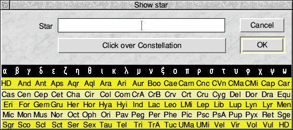
Bright stars will usually have an ID with a single Greek letter, though sometimes a number is needed as well. Otherwise there may be one or more roman letters of either case such as G Scorpii, d Centauri, ET Virginis. Or the star may have a Flamsteed number, as 110 Tauri. If the star has none of these IDs then it is not found with reference to its constellation, but from its Harvey-Draper (HD) catalogue number. NightSky does not know about SAO numbers, and those stars (around 1%, all faint) that have none of the above identifications are anonymous (they are filed as HDO, printed as "- - -" in the star ID window). Usually you will want to employ this routine to locate a bright star, a double star or a variable star, and you will not often need to use HD numbers.
Deep Sky is greyed out unless plotting deep sky objects is enabled If so enter either M and a number for the Messier Catalogue objects, or NGC and a number for the others.
Once a search has been started, NightSky behaves as follows.
NightSky does not check the size of its map window in its Find routine but assumes it is full-screen, so open the map to full size before using it.
The Information Windows
The information windows for the moon and for the sun and planets have been described already in this chapter. For deep sky objects the window only offers the name and type of object and its position (altitude, azimuth, R.A. and Declination). If you want more information then tag it and add your own comments.
The Star Information Window
NightSky knows quite a lot about each star, and fairly comprehensive help on the fields and their contents for this window is available if you have the 'Help application running as well as NightSky. The top four icons refer to the point where SELECT was clicked to start a search routine; if the window is opened after Find has been used the Pointer R.A. and declin'n boxes will be empty and the two boxes above them will have the actual altitude and azimuth of the star. The star's actual position (in 2000.0 unless you have processed the catalogue) is shown underneath its ID. The constellation is abbreviated to its standard 3 letter code if, as here, there is a proper name: otherwise it is spelled out in the full Latin (possessive) form used in the Find window.
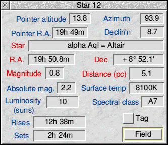
Star distances, being immensely great are measured in a special unit called the parsec (the Astronomical Unit, like the kilometre is simply too small for the purpose). One parsec is the distance of a star which would have a parallax of 1 second of arc (1/3600 ) on a baseline equal to the radius of the earth's orbit. No star is this close and no parallax was measured until 1820 because the angle is so very tiny. 1" is the angle subtended by a coin 1 centimetre in diameter at a distance of about 210 kilometres. Absence of perceptible parallax was a valid argument in olden times for the earth being at rest rather than revolving around the sun, though naturally arguments based on the absence of a small effect arc always likely to fail when measurement techniques advance sufficiently. 1 parsec is the distance travelled in free space by light (or any other form of electromagnetic radiation) in 3.26 years, hence it is 3.26 Light Years (LY), a unit often used in astronomical literature aimed at the general public.
The absolute magnitude of a star is what its visual magnitude would be at a standard distance of 10 parsecs (32.6 Light Years). It enables comparisons between stars to be made easily. Since Procyon is one of the nearest stars, it "would actually look fainter at lOpc than it does in the sky. Most of the bright stars you can see in the sky are actually much further away than lOpc, and so have absolute magnitudes lower (brighter) than their actual visual ones. They are thus in themselves much more luminous than Procyon is, or the sun for that matter. The luminosity field repeats this information in a different way, by comparing the energy output of the star in the visible region with that of the sun. At 7 suns, Procyon is well above average for all the stars in the galaxy, but well below it for the stars we can see with the unaided eye, as in this category very bright but far away objects are, naturally, much over-represented.
Surface temperatures are in degrees kelvin (subtract 273 to get the ordinary Celsius value),. The hotter a star's surface is, the more it will radiate and it will also be different in colour. For example, an electric iron is perceptibly hot, you can feel the radiant heat (infra-red radiation) coming from it, but it does not glow. Heated further an object glows red like a poker in a fire; here most energy is still emitted in the infra red. The sun is yellowish-white in colour (but red through haze or at sunset because the sky is blue) and emits principally visible light though there is still much TR and also some UV. A star oven hotter than the sun may radiate mainly in the ultra-violet, in which case it would look blueish-white to us. To see this compare the stars in Orion's bell (blue) with Betelgeuse (reddish- orange); or Arcturus (orange) with Spica (blue). Visible star's surfaces range from under 3000K (cool, red) to well over 30000K (hot, blueish- white).
Star temperatures are measured by comparing the relative intensities of the radiation of different kinds (wavelengths) in the energy received. These measurements enable a spectral class of the star to be assigned, and it is from these that NightSky estimates the actual temperature. There are eight main classes, in order from the hottest 0,B,A,F,G,K,M,N (with the immortal mnemonic Oh Be A Fine Girl Kiss Me Now). These strange letters reflect not so much astronomers' problems with the alphabet, as the difficulty they had in sorting all this out in the 19th Century. The sun is a G class star and so distinctly cooler than Procyon: F5 means middle of the F class, FO being nearly A and F9 nearly G. However the subdivisions are often uncertain, even meaningless as in F9.5 (indistinguishable from GO).
Stars and deep sky objects can be tagged; the button indicates there is a record for Procyon. Click on the tag icon to read or edit this text, or to add comments for an untagged star if you have write access.
Finally (if the object is above the horizon) click on Field to view it at the centre of a field 10° across. This is particularly useful for printing out maps suitable for studying variable stars, many of which are tagged already for you, and also for printing out the field of stars surrounding the faint planets Uranus and Neptune. To find Uranus and identify it from such a map is a fairly easy and satisfying beginner's project. The hardest part is to locate the field itself in the sky.
RealTime (F9)
This menu option leads to one of the most important and powerful feature? of NightSky, its ability to refresh a map automatically and in a manner that you decide.
When NightSky owns the caret, F9 is an important key as it will toggle the present real time mode, that is turn it off when it is on and vice versa. When you plot a map using one of the NOW options, real time mode is selected, with the map refreshed every minute and the time plotted advanced the same amount. The RealTime menu option allows you to vary these parameters.
Refresh every ->
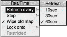
This controls how frequently the map is refreshed. By default this is every minute. If you increase the rate to twice a minute you can still open the map menu or do a drag operation to zoom in on an area. On the 10sec setting however, the processor works almost flat out, each refresh beginning to be calculated only a second after the last was finished. This is the best setting used for viewing events such as eclipses. You can stop (and then restart) the animation with F9. If F9 seems ineffective in gaining you control of the machine, NightSky does not own the caret: click anywhere in the map window and press F9 again.
Step ->
This leads to a small dialogue box which is used to control the time increment between plots. By default it is one minute, but any multiple (up to 99) of a minute, hour, day, month, year or century can be chosen. When the step is in Centuries, it is assumed that you are interested in the changes in star positions caused by precession, so the catalogue is processed for every update. Likewise 10000 years is to study the effects of the stars' actual motions through space (proper motions) on the appearance of our familiar constellations. For this setting only a multiple of 1 is allowed, and precession itself is ignored. Also, you will probably want to Lock on a particular star (see below). In addition, plotting of the planets will quickly cease. NightSky cannot preserve even rough accuracy over such long periods for solar system calculations, so anywhere in NightSky, if the year calculated is more than one whole precessional cycle (27000 years) from the present, planet calculation is automatically cancelled to avoid crashes. You will need to re-select it again when you have finished the animation. Also remember that all precession and proper motion studies will go much faster when a small star catalogue is installed, such as the 5.4 minimum size you can set in the options Window (Chapter 4).
Wipe old map
This is usually ticked (chosen). Click on it to toggle this state. If it is deselected then the old map will not be erased at the start of each refresh. Use this to
You can get the real thing by pointing a camera at an area of dark sky (no moon or street lighting interfering) and leaving the shutter open for minutes to hours. You can then compare with the NightSky view. You will probably want to cancel labelling of planet, star and constellation names, and also deselect constellation joins and boundaries and any co-ordinate grid you usually show before trying out this option.
Lock onto ->
This important choice leads to the Find submenu again. When you make a choice there, the chosen object will remain at the centre of successive views. It is essential to choose a body to Lock onto in large scale views, say of an eclipse, otherwise the earth's rotation will move the object of interest out of the view. Once a body has been chosen as a lock, you can click on Lock onto to toggle the locked state. If the lock body sets during the animation, then NightSky will continue incrementing the time and calculating without refreshing the screen until the body rises again, when the screen will be updated. This may take some time, but you can always use F9 or Escape to abort the animation.
Lock onto Earth's Shadow
If a map is drawn for a time very close to New Moon and the sun is below the horizon, then the Earth's shadow at the distance of the moon is drawn. When this has been done, you can select Shadow rather than Sun as a Lock object. This allows you to keep the shadow centred on the screen as you view a lunar eclipse.
Hint - many animations such as views of Jupiter's satellites or of transits of Venus or Mercury are essentially the same as viewed from any point on earth where the body in question is visible. In such cases view the events from either the North or South Pole, depending in which hemisphere of the sky the object is located. You will not then be troubled by the object setting, and the view will also be simplified by the fact that North (or South) is always "up" in the display.
Restricted ->
This may be chosen only after a Lock Object has been defined. When chosen, only the following objects are plotted:
In other words no pass is made through the star catalogue with all the calculation that that involves. This greatly speeds up views of eclipses for instance. However for each moment considered, a full calculation of the solar system is made, so screen refreshes are certainly not instantaneous.
Starting RealTime mode
When you click with SELECT on one of the choices anywhere in the RealTime menu, plotting will begin within a second or so; if there are several parameters to set, use ADJUST to make the choices. This will keep the menu structure open, and, just as important, plotting will not begin immediately so you have time to make the other settings.
Time Flow
When NightSky is in real time mode, pressing Ctrl-R will reverse the flow of time, that is you can view the event both with time flowing backwards and normally. After a Ctrl-R, all animations will run backwards until you press Ctrl-R a second time. The current Ctrl-R setting is remembered if you just press F9 to stop and F9 or the RealTime submenu to restart RealTime mode. When a new map is plotted from the Draw a Map Menu or via key-presses F5-F8 , normal time flow is restored.
Zoom ->
This is the second method NightSky offers for changing the scale of your map. Use it mainly for zooming out to make the scale smaller: when you are zooming in it is more straightforward to demarcate the desired area of interest by means of a SELECT-drag operation. The present menu choice is also useful when you want to set a predetermined value to the field, or to operate at a very large scale.
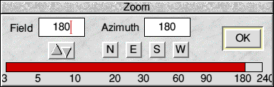
Set the value by entering a number in the field box (Return here is equivalent to a click on Ok - it starts the new map), by clicking anywhere on the red slider or its outer frame, or by dragging the slider to right or left. The bump arrows when clicked causes the field to be increased (SELECT ) or decreased (ADJUST ) by 1 degree. You can accept the current direction of view, or force it to a chosen value by entering a value in the Azimuth box or clicking on one of the four direction icons.
The field used is always a whole number of degrees down to 2°, although 3° is the smallest field you can set with the slider. However you can type in a smaller value, NightSky will adjust it to be a multiple of 1/8 of a degree down to the smallest field supported, which is 1/8°. At this scale the phases of the planetary discs become visible and of course Saturn's rings in correct orientation and size. For Jupiter's satellites a somewhat larger field of 1/2° to 1° is better, and 1° is also the optimum scale for viewing eclipses and occultations.
Label ->
Follow the arrow across this menu option and you are presented with an editable field in which you can enter a line of text. This will then be printed on the map at the point where you clicked MENU, and in the font, size and colour set for user labels. Click again on label and the same text will be printed again at the new site. You set the font (which could be the system font) and size to be used in the Options Window (Chapter 4), or by using the keyboard shortcut Ctrl-F1 which will bring up a menu that allows these to be chosen and set.
Map Title ->
The standard NightSky title bar display for a map gives place name, latitude, longitude, field size, direction of view and time in the standard astronomical format of year, month, day, hour, and minute. You can edit this, to something much simpler perhaps via this menu option. The new title will be displayed in the window title bar, and also will be saved away if Draw or Sprite saving is in force (but not CSV instructions). Your edited title is not however preserved over map refreshes, not even over plotting an enlargement, so it is only worthwhile using this menu choice when you know that what is on the screen is what in fact you want to save. An alternative procedure (and the only one feasible when automatic saving is in force) is to edit the Draw file produced by NightSky. The title is a text object like any other and you can edit it in Draw; it is necessary to Ungroup first.
New Map ->
The final menu option on the map menu leads to another copy of the Draw a Map menu. Any new map plotted will have the field and orientation of the current map (when the choice is made from the icon bar copy of this menu, these are read from the file of places). When a map is on-screen, the function key shortcuts F5 -F8 duplicate the first four choices on this submenu. The Options Window is the subject of the next chapter.
Additional Note
Zooming in on Jupiter's Satellites
At high magnifications (Field set to 0.5° to 1°) the current appearance of the satellites of Jupiter can be seen. These are shown as they are in the sky, not as seen in an inverting astronomical telescope. They are coded with colours 11-14 of the current screen palette, so normally lo (satellite I) is red, Europa (II) is cream, Ganymede (III) is dark green and Callisto (IV) is orange. NightSky does not at present predict occultations, transits etc for the satellites. However the screen generated should correspond closely to what you can observe with good binoculars or (inverted) a small telescope. You can observe their motions in real time by starting an animation, with NightSky locked on to Jupiter and (preferably) the Restricted switch on. A step of 1 or 2 hours is suitable. There will be a jump of twelve hours or so each time Jupiter sets; continuous viewing can be obtained by choosing as the place used the pole of the hemisphere in which Jupiter is. From 1993 to 1998 this is the South Pole. The views are reliable for about 25 years either side of 1980.