 Geography plays an important role in law enforcement. Response capabilities often rely on a variety of data from multiple agencies. The capability to access and process information quickly and deploy resources where needed can be mission critical.
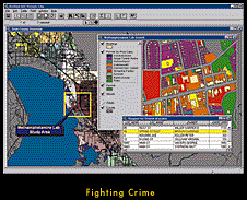
Geographic information system (GIS) software from ESRI supports this mission by using geography and computer generated maps as an interface for integrating and accessing massive amounts of location-based information. Many law enforcement agencies rely on GIS to access real-time information, make better decisions, and respond more effectively. Here are some areas where geographic data can make a difference.
Crime Analysis
The vast majority of information used in law enforcement is map based. Agencies need to display the location of incidents and be able to view incidents by categories, time, or date. GIS offers this flexibility for viewing data and facilitates a wide range of map-based analysis. For example, incidents can be displayed by beat, reporting district, or zone. Advanced GIS capabilities can generate incident density and contour maps that can be used to predict the probability of crimes occurring. Law enforcement agencies use GIS in records management.
Communications
In communications, GIS is used to display incident locations, vehicle locations, and positions based on global positioning systems (GPSs). Further, GIS can be used as the engine to generate the route. Law enforcement agencies are building mapping capabilities into both dispatch centers and individual patrol vehicles.
Operations
The operations division of most law enforcement agencies consists of patrol, crime analysis, investigations, special units, and planning. These are the units that conduct the majority of analysis and need to have tools that facilitate research into specific types of incidents. GIS in this arena is developed as a series of end user applications that meet the specific needs of each unit.
Records Management
Records management maintains the incident data used in GIS. Incidents, arrest reports, calls for services, and citations make up a small portion of a law enforcement agency's record management system. Often the GIS map data need to be coordinated with records management data for optimum efficiency.
Vehicle Routing and Tracking
GIS is used as a decision support module for locating and routing vehicles when street map data are included in the dispatcher's window of a computer-aided design (CAD) system or in the vehicle. GIS may also be used to create routes and direction to or from an incident location. Dispatch managers can also track the location of vehicles through GPS transponders attached to the vehicles along a GIS base plan at the dispatch terminal.
If you would like to know more, we invite you to explore our many informational and downloadable resources.

