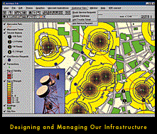
 The power just went out! Which neighborhoods are affected and how fast can service be restored? Maps are very important to electric and gas utilities. Maps show the location of key equipment and distribution lines...critical information when solving problems such as power outages. In an outage situation, GIS helps utilities get homes, businesses, and hospitals back in service quickly.
GIS is also helping electric utilities worldwide to reduce costs and increase productivity in a newly competitive market. Quality map information helps utilities be better at so many things including engineering, operations, emergency preparedness, customer service, marketing, and finance.
Engineering
Through the use of GIS, the utility user can plan, design, estimate, and choose cost-effective solutions to properly serve the rate paying customer. GIS also allows the utility user to analyze the performance of the electrical network by performing a variety of calculations that use a model of the electrical distribution system to evaluate its performance. The GIS will allow the user to identify features that meet certain criteria, examine relationships between features, analyze data, and retrieve/display results more quickly in both geographic and tabular form.
Operations
Operations involves maintenance and service restoration. GIS streamlines and provides a geographic representation of preventive and periodic maintenance processes. The service restoration group is responsible for providing reliable and accurate communication with customers during an outage situation. With the trouble call and outage management process, the GIS allows the utility to restore services quickly and safely.
Marketing and Customer Service
Demographics and service area analysis are two areas of concern for marketing. Through the use of GIS, the utility is able to locate where the eligible customers are that are not currently being served, and identify those high use/high value customers. GIS can help the utility provide its customers with reliable service. For example, if a large company or plant is moving into the service area, then the utility can provide them with information on what is the best available and the most reliable service location.
Finance
GIS provides the utility with a geographic perspective of the service area and location to help determine the fixed cost of utility to the customer. Geographic representation also allows the utility to obtain an accurate inventory of the number of poles that are owned by the utility company but are used by other companies as well, so that the utility can then determine how much to bill each company. In addition, GIS allows the utility user to automate the design environment and streamline this process.
If you would like to know more, we invite you to explore our many informational and downloadable resources.

