 Gorges de Daluis
Provence-Beyond (Beyond the French Riviera) ®
Alpes-Maritimes (06)
Altitude: 538-819 m
Nearby:
[ Annot | Entrevaux | Guillaumes | Valberg ]
Photos:
larger view of the Gorges de Daluis entrance
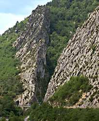 This is a deep, narrow gorge on the upper Var river.
If you're travelling east-west between Annot and Entrevaux,
either on the N202 or the Train des Pignes,
you'll see a deep V-slot in the high rock walls to the north (photo).
This is a deep, narrow gorge on the upper Var river.
If you're travelling east-west between Annot and Entrevaux,
either on the N202 or the Train des Pignes,
you'll see a deep V-slot in the high rock walls to the north (photo).
The D902 goes up through that slot into the Gorges de Daluis, winding up the west side of the canyon and high above it, with magnificent views. The road passes by Sausses, Daluis, then with some real switch-backs and tunnels to Guillaumes at the northern end of the gorges. From Guillaumes the D28 goes east to Valberg, Beuil and St. Sauveur, or the D2202 continues on northeast to the Col de la Cayolle and Barcelonnette.
The Grottes du Chat caves are located just 300 m above the village of Daluis, 8.5 km north of the N202.