 TAServices is a system developed by ITS to make the latest engineering and research information available to all of the telecommunications community on a cost basis. It is built around 18 computer programs that have been designed to be user friendly and intelligent, so that the user can access the required information and data with a minimum of either computer expertise or in-depth knowledge of radio propagation or system engineering. These programs and data bases are updated as new data and methodologies are developed in the many engineering and research programs at ITS. Currently, over 120 organizations make use of this service, of which the majority are private industry users. Recent upgrades to TAServices include the incorporation of a 60-MIPS workstation and more detailed databases on CD-ROM. A new bulletin board system offers access to these programs and will provide an expanding amount of information on recent telecommunications activities. The following is a description of two of the programs:
RAPIT - This program gives the user on-line access to the latest in VHF/UHF propagation models. It can calculate basic transmission loss and other engineering information such as received signal levels over irregular terrain for the design or analysis of broadcast and mobile radio systems. The program has a broad range of options that allows the user to easily look at the effects on his received signal from changes such as the antenna height, etc.
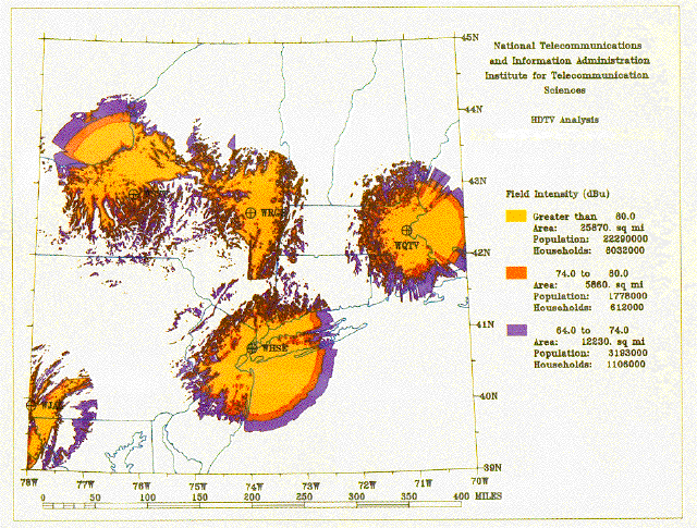
CSPM - Communication System Performance Model is a program that determines the system performance of mobile and broadcast systems in detailed output plots of signal intensity, as shown in the sample plot. This program allows the user to have his output plotted on clear plastic to a specified scale for overlaying on top of widely available geopolitical maps. CSPM uses the ITS irregular terrain model in point-to-point mode. Other options allow combining coverage from several transmitters, to show the total coverage from a network of stations or to show regions of interference within the area of interest. It uses the ITS demographic density data base to calculate population, households, and area covered within each of the user- defined signal ranges. New options allow plot files to be rapidly down-loaded for near-real-time plotting by the user.