
Welcome to the Tatra Mountains Virtual Tourist. These pages contain the tourist trails diagram, over 260 pictures and some information about the Tatras.
Last 86 pictures are available only here.
Welcome to the Tatra Mountains Virtual Tourist. These pages contain the tourist trails diagram, over 260 pictures and some information about the Tatras.
Last 86 pictures are available only here.
 Where are the Tatra Mountains ?
 The Tatras view from satellite
 The mountain huts in the Tatras
The following diagram shows many objects of Polish and Slovak Tatras, including tourist trails, roads, peaks, mountain huts, cities and villages, etc. It is Main Map of the Tatras. For zooming in, click on selected point of this map.
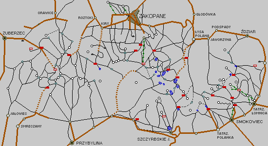 |
You can select the Tatras region by name instead of using above map, or you can select the pictures group, single picture or described picture from the list by clicking on the one of the following buttons:
 List of the Tatras regions
 Groups of pictures list
 List of all pictures
 List of all described pictures

 | informacje o po│o┐eniu geograficznym Tatr |
 | zdjΩcie satelitarne Tatr z opisem |
 | informacje o tatrza±skich schroniskach (mapa, zdjΩcia) |
 | schemat tatrza±skich szlak≤w turystycznych |
 | 265 zdjΩµ tatrza±skich widok≤w (rocznie przybywa kilkadziesiat nowych zdjΩµ) |
 | 95 opisanych zdjΩµ (nazwy szczyt≤w, prze│Ωczy, dolin, itp.) |
 | mo┐liwo£µ automatycznego wyszukiwania zdjΩµ z widokiem wybranego tatrza±skiego miejsca (baza danych zawiera oko│o 470 nazw) |