


LeyFind
Martin Carradus
DISCLAIMER - AGREEMENT
Users of LeyFinder must accept this disclaimer of warranty:
"LeyFinder is supplied as is. The author disclaims all warranties, expressed or implied, including, without limitation, the warranties of merchantability and of fitness for any purpose.
The author assumes no liability for damages, direct or consequential, which may result from the use of LeyFinder."
LeyFinder is a "shareware program" and is provided at no charge to the user for evaluation. Feel free to share it with your friends, but please do not give it away altered or as part of another system. The essence of "user-supported" software is to provide personal computer users with quality software without high prices, and yet to provide incentive for programmers to continue to develop new products. If you find this program useful and find that you are using LeyFinder and continue to use LeyFinder after a reasonable trial period, you must make a registration payment of £10 (UK) or $20 (US) to Martin Carradus. The £10 (UK) or $20 (US) registration fee will license one copy for use on any one computer at any one time. You must treat this software just like a book. An example is that this software may be used by any number of people and may be freely moved from one computer location to another, so long as there is no possibility of it being used at one location while it's being used at another.
Just as a book cannot be read by two different persons at the same time.
Commercial users of LeyFinder must register and pay for their copies of LeyFinder within 30 days of first use or their license is withdrawn. Site-License arrangements may be made by contacting Martin Carradus.
Anyone distributing LeyFinder for any kind of remuneration must first contact Martin Carradus at the address below for authorization.
You are encouraged to pass a copy of LeyFinder along to your friends for evaluation. Please encourage them to register their copy if they find that they can use it. All registered users will receive a copy of the latest version of the LeyFinder application.
Description
LeyFind finds straight lines of ancient sites given their grid references, the minimum wanted in a line and the chosen 'accuracy' of the line. Plots the sites and found lines on a 'map' of the chosen area. Map can be saved to a file, both before and after plotting of lines. This program is designed solely for use with grid references on grid systems not extending over more than 600 miles (1,000 kilometres). It is not designed for use with latitude and longitude and does not employ any spherical trigonometry in its calculations.
Information needed by the program and Options offered:
The Two Algorithms:
The basic (Quick) algorithm goes through all pairs of sites, establishes the line between them, then runs along it looking for other sites on the line within the desired degree of accuracy. At the same time all pairs of sites along the line are eliminated from further consideration. This is done by keeping an internal look-up table which records whether any particular pair has been considered or not before.
The elimination of pairs along the line is done without any regard to the direction of the line between them. This would be correct if all the points along the line lay exactly on it. However they usually don't and the algorithm tends towards radiating lines because any crossing lines tend to be suppressed. The second algorithm takes account of crossing lines by only eliminating pairs along an established line if the line between them lies sufficiently close in terms of its gradient (angle of slope). The user supplies an angle in degrees within which lines must lie to be eliminated. The first algorithm does find valid lines, but tends to exaggerate the radial look of the final plot of the found lines.
The overall problem with both algorithms is that it is conceivable that lines could exist where none of the points lie exactly on them. Both algorithms require that at least two points lie on it within the degree of accuracy of the swathe cut by the line.
Fixed Scan or Random Scan:-
A fixed scan goes through the pairs of sites in a systematic order i.e. site 1 with site 2, site 1 with site 3, site 1 with site 4 etc.
A random scan goes through the pairs in a non-systematic order e.g. site 6 with site 9, site 2 with site 7, site 4 with site 6 etc., but in such a way that all pairs are considered.
Fixed Start or Random Start:
A fixed start always starts with the same pair i.e. site 1 with site 2 A random start chooses a different pair each time the program is run. Hence a fixed start guarantees the same result every time, but a random start will tend to produce a different result every time.
In order of 'randomness' (from least to most), there is:
- 1.Fixed Scan, Fixed Start.
- 2.Fixed Scan, Random Start.
- 3.Random Scan, Fixed Start.
- 4.Random Scan, Random Start.
Creation of New File:
Offers the user the option of creating a file of grid references and immediately analysing it for ley lines. A new file may be created either internally or externally. An existing file can be appended to, to add additional sites. A record number is supplied to which you supply an easting, northing and site name. All three must be supplied, then click on the 'Next' button to move onto the next record. Click on the 'Close' button to close and end the file.
Otherwise the program will ask for...
Name of file of map co-ordinates:
This is the file containing the co-ordinates of the sites. The format of the file is a set of lines of values, each line consisting of a site number (not necessarily in any order), followed by the easting, followed by the northing, followed by a string of up to 30 characters. (The string being a name associated with the site.) These values are separated by commas. The easting and northing should be whole numbers and the string starts with a capital 'X' or small 'x' for an highlighted site or anything else for a un-highlighted site. The string can simply only be a single character if there is no name associated with the site. Names need not be unique. File should end with a new line.
This file may also be created by using something like Edit or DeskEdit.
It is checked as it is read in an elementary way. There should be at least ten sites in the file, but not more than 1000. Estimated time for processing the full 1000 sites is around two and a half hours with my StrongArm and RISCOS 4, less for faster chips.
Automatic Scaling:
Will adjust the scaling to fit in all the sites on the screen.
Will also adjust the scaling so that it is the same east-west as north-south. Otherwise usually unequal scaling in the two directions.
Manual Scaling:
The minimum and maximum co-ordinates east-west and north-south are chosen by the user, so that any area of interest can be focused on.
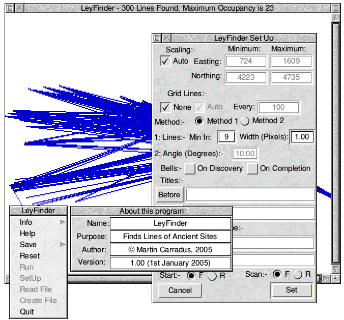
Grid Lines:
These are horizontal and vertical lines that indicate the change of grid reference across the screen. If you choose this option a suitable grid interval is suggested, which may be over-ridden. Program will not allow too many grid lines. Grid lines do not erase the supplied site points.
Sites in Line:
One of the two most important parameters. It is the number of sites found in a line below which the line will be rejected. Too small and the map will fill with lines. Too large and no lines will be found. It has been found that 15 is a reasonable amount to start with for about 200 sites.
Width of Line:
The second most important parameter. This is the number of pixels across the line within which a site will be considered to lie.
Can be fractional. This is across both sides, so if a value of 1.5 is chosen, the swathe cut by the line will extend by 0.75 pixels on either side. The screen mode within which this program operates means that the pixel (elementary part of image) is twice as high as wide.
Consequently the width of the swathe is adjusted so that when the line is near horizontal it is wider than when the line is near vertical. It is suspected that near horizontal lines will tend to be detected more easily than those near vertical. Points that lie too close together on the screen will be rejected, since the line through them cannot be determined accurately within the confines of the co-ordinates supplied. If the width is too small, no lines may be found. If the width is too large, many inaccurate lines may be found. A starting value of one pixel is suggested.
Bell Sound:
Single normal bell sound on each discovery and/or high-pitched bell sound on completion.
Titles:
An option of having a title after the plotting of points and before the plotting of lines and/or one after the plotting of lines.
Up to 72 characters including embedded spaces. Neither grid nor title before will erase the points on the screen as the points are plotted last.
ScreenSave:
Option of saving the screen to a RISC OS Sprite file, either after plotting of points or after plotting of lines. No recovery is offered if the file names the user supplies are incorrect in any way, but a message will indicate the ScreenSave failure. A 'Saveas' panel appears, where you may drag the file icon with the mouse to a suitable directory, if required.
Screen Display:
Points, Grid Lines and Title (if chosen). Chosen points highlighted in red. Rest in black. Background white. Percentage through process shown by an hourglass mouse pointer. On the title bar the actual number of lines found so far followed by absolute maximum found in all lines.
Holding down any key at at any time will halt the process, otherwise the completion of process, or a maximum of 1000 lines being found will also halt the process.
On Completion
The found lines are plotted. Those of maximum occupancy are plotted in magenta, the rest in blue. If there are none or a maximum of 1000 has been found, a message is displayed. The screen is saved, if this option was chosen. Close the window to end the program. From the bar icon menu, click on 'Reset' to repeat the process, possibly with a new file, or an old one with new run-time parameters.
Warning
This program merely takes the donkey-work out of finding ley lines and the accuracy of the results are not guaranteed. It does not substitute for actual investigation on the ground and map. Britain, in particular is virtually littered with ancient sites, so almost anything will fit. Straight lines of telephone boxes have been found in the past! The algorithm (method) used seems to bias in favour of lines radiating out of certain sites with the fixed scan. The random scan was introduced in an attempt to get rid of this bias. It is hoped to give the likelihood that the line could not have occurred entirely by chance, plus more statistics on the found lines in future versions.
Comments, queries, curses, and praise to:-.
Martin Carradus,
Leaf Mindcraft,
c/o 27 Wells Road,
ILKLEY,
West Yorkshire.
LS29 9JE.
U.K.
Enclose s.a.e. if you want a reply.
File 'Stones' within this application contains eight figure grid references of some of the cup-and-ring marked stones on Rombalds Moor (Ilkley Moor). Stones thought to date from 1500-1800 B.C. and no one is totally sure of the significance of the markings or even exact antiquity. Such markings are not entirely unique within this area or within Britain (know of others in Northumberland and Galloway). Even eight figure grid references only reduce the inaccuracy to a ten metre square, which is about the floor area of an average house, so not that accurate considering the size of the stones and the markings.
Would probably have to use satellite navigation to get any degree of accuracy and I don't know how these grid references were worked out in the first place. Grid references obtained from:
"The Carved Rocks On Rombalds Moor" West Yorkshire Metropolitan County Council 1986 ISBN 0 86181 008 2. Thought now to be out of print. Not all those available were put in the file.
There is now (2005) a more complete listing of the cup-and-ring marked rocks mentioned above in 'Prehistoric Rock Art of the West Riding' by the 'West Yorkshire Archaeology Service', editors K.J.S. Boughey and E.A. Vickerman, (2003) ISBN 1 870453 32 8, ISSN 0959-3500.
Information on those markings in Galloway can be obtained from:
"The Prehistoric Rock Art of Galloway and the Isle of Man" Ronald W.B.Morris Blandford Press 1979 HardCover: ISBN 0 7137 0974 X PaperBack: ISBN 0 7137 0975 8 Might also be difficult to get - I found it in a remainder book shop.
The files 'Test' and 'Test2' are test sets of grid references to demonstrate that this program really works! For 'Test' choose an occupancy of 10 and a width of 1.0. For 'Test2' choose an occupancy of 5 and a width of 10.0.
Both files are buried inside this application. Use 'Internal' to get them!
Good Luck in your investigations, but don't come to wild conclusions!
Martin Carradus